Yamasá elevation
Yamasá (Monte Plata), Dominican Republic elevation is 89 meters and Yamasá elevation in feet is 292 ft above sea level [src 1]. Yamasá is a populated place (feature code) with elevation that is 74 meters (243 ft) smaller than average city elevation in Dominican Republic.
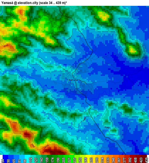
Below is the Elevation map of Yamasá, which displays elevation range with different colors. Scale of the first map is from 34 to 439 m (112 to 1440 ft) with average elevation of 125.1 meters (=410 ft) [note 1]
These maps also provides idea of topography and contour of this city, they are displayed at different zoom levels. More info about maps, scale and edge coordinates you can find below images.
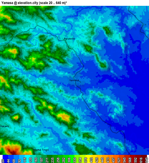
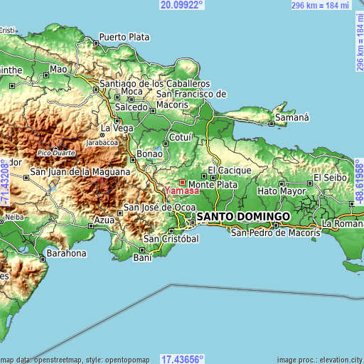
| \ | Map #1 | Map #2 | Topo.Map |
| Scale [m] | 34..439 m | 20..640 m | × |
| Scale [ft] | 112..1440 ft | 66..2100 ft | × |
| Average | 125.1 m = 410 ft | 127.3 m = 418 ft | × |
| Width | 9.25 km = 5.7 mi | 18.51 km = 11.5 mi | 296.1 km = 184 mi |
| Height | 9.25 km = 5.7 mi | 18.51 km = 11.5 mi | 296.1 km = 184 mi |
| ↑Max Latitude | 18.814752° | 18.856344° | 20.09922° |
| Latitude at center | 18.77315° | 18.77315° | 18.77315° |
| ↓Min Latitude | 18.731537° | 18.689915° | 17.43656° |
| ← Min Longitude | -70.069775° | -70.113721° | -71.43208° |
| Longitude center | -70.02583° | -70.02583° | -70.02583° |
| →Max Longitude | -69.981885° | -69.937939° | -68.61958° |
Nearby cities:
Cities around Yamasá sort by population:
• Santo Domingo Oeste elevation 58 m
30.5 km,  174°
174°
• Villa Altagracia 178 m
18.9 km,  233°
233°
• Sabana Grande de Boyá 291 m
31 km,  52°
52°
• Monte Plata 55 m
25.7 km,  81°
81°
• Cristo Rey 31 m
31.9 km,  162°
162°
• La Agustina 31 m
31.9 km, 162°
• Piedra Blanca 180 m
31.6 km,  284°
284°
• Esperalvillo 148 m
4.8 km,  347°
347°
• Cevicos 95 m
26.2 km,  10°
10°
• Los Botados 59 m
5.6 km,  144°
144°
• Don Juan 59 m
10.3 km, 54°
• Juan Adrián 356 m
32.8 km,  268°
268°
Multilingual:
 En español:
Yamasá elevación 89 m.
 En France:
Yamasá élévation 89 m.


Sources and notes:
- [note 1] Map square and city borders are not equal. Map elevation data is calculated only from area inside that square.
- [src 1] Elevation data from geonames database provided with same terms of usage.
- [src 2] The elevation map of Yamasá is generated using elevation data from NASA's 3 arcsec (90m) resolution SRTM data.
- [src 3] Base (background) map © OpenStreetMap contributors tiles are generated by Geofabrik and OpenTopoMap.
Copyright & License:
This Yamasá Elevation Map is licensed under CC BY-SA. You may reuse any part from this page, if you give a proper credit by linking to this URL:
 More info on terms of use page.