Vejen elevation
Vejen (South Denmark, Vejen Kommune), Denmark elevation is 41 meters and Vejen elevation in feet is 135 ft above sea level [src 1]. Vejen is a seat of a second-order administrative division (feature code) with elevation that is 14 meters (46 ft) bigger than average city elevation in Denmark.
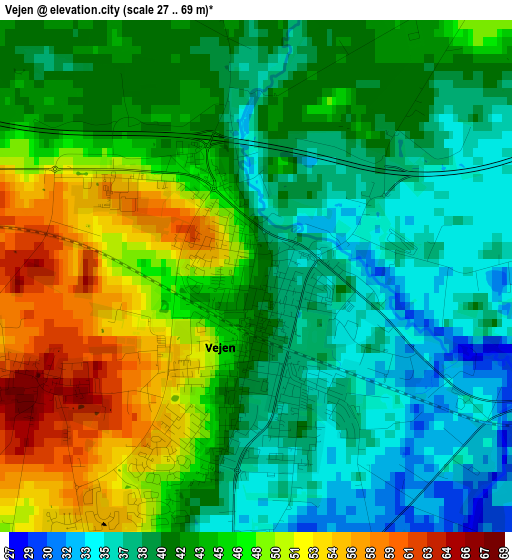
Below is the Elevation map of Vejen, which displays elevation range with different colors. Scale of the first map is from 27 to 69 m (89 to 226 ft) with average elevation of 43.1 meters (=141 ft) [note 1]
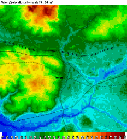
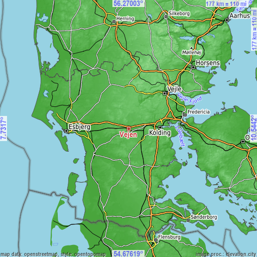
These maps also provides idea of topography and contour of this city, they are displayed at different zoom levels. More info about maps, scale and edge coordinates you can find below images.
| \ | Map #1 | Map #2 | Topo.Map |
| Scale [m] | 27..69 m | 19..86 m | × |
| Scale [ft] | 89..226 ft | 62..282 ft | × |
| Average | 43.1 m = 141 ft | 42.2 m = 138 ft | × |
| Width | 5.54 km = 3.4 mi | 11.08 km = 6.9 mi | 177.2 km = 110.1 mi |
| Height | 5.54 km = 3.4 mi | 11.08 km = 6.9 mi | 177.2 km = 110.1 mi |
| ↑Max Latitude | 55.506065° | 55.530944° | 56.27003° |
| Latitude at center | 55.48117° | 55.48117° | 55.48117° |
| ↓Min Latitude | 55.456259° | 55.431333° | 54.67619° |
| ← Min Longitude | 9.094005° | 9.050059° | 7.7317° |
| Longitude center | 9.13795° | 9.13795° | 9.13795° |
| →Max Longitude | 9.181895° | 9.225841° | 10.5442° |
Nearby cities:
Cities around Vejen sort by population:
• Kolding elevation 8 m
21.1 km,  87°
87°
• Bramming 15 m
27.6 km,  267°
267°
• Billund 58 m
28.1 km,  356°
356°
• Vamdrup 37 m
11 km,  122°
122°
• Brørup 60 m
7.6 km, 270°
• Holsted 26 m
14.2 km,  283°
283°
• Rødding 35 m
13.7 km,  200°
200°
• Christiansfeld 28 m
25.9 km, 121°
• Lunderskov 38 m
10.2 km, 88°
• Gram 36 m
22 km,  194°
194°
• Egtved 60 m
18.4 km,  35°
35°
• Sønder Bjert 24 m
27.3 km,  96°
96°
Multilingual:
 En español:
Vejen elevación 41 m.
 En France:
Vejen élévation 41 m.
 Auf Deutsch:
Vejen Kommune höhe über dem Meeresspiegel ist 41 m.

Sources and notes:
- [note 1] Map square and city borders are not equal. Map elevation data is calculated only from area inside that square.
- [src 1] Elevation data from geonames database provided with same terms of usage.
- [src 2] The elevation map of Vejen is generated using elevation data from NASA's 3 arcsec (90m) resolution SRTM data.
- [src 3] Base (background) map © OpenStreetMap contributors tiles are generated by Geofabrik and OpenTopoMap.
Copyright & License:
This Vejen Elevation Map is licensed under CC BY-SA. You may reuse any part from this page, if you give a proper credit by linking to this URL:
 More info on terms of use page.