Haselbachtal elevation
Haselbachtal (Saxony), Germany elevation is 224 meters and Haselbachtal elevation in feet is 735 ft above sea level [src 1]. Haselbachtal is a seat of government of a political entity (feature code) with elevation that is 34 meters (112 ft) smaller than average city elevation in Germany.
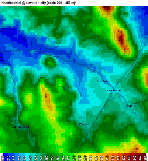
Below is the Elevation map of Haselbachtal, which displays elevation range with different colors. Scale of the first map is from 204 to 353 m (669 to 1158 ft) with average elevation of 248 meters (=814 ft) [note 1]
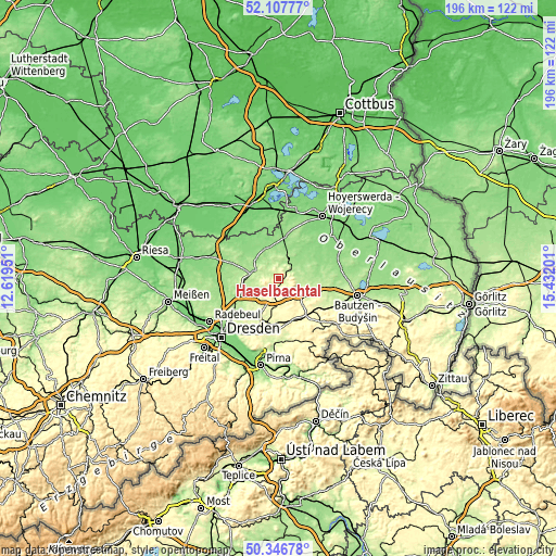
These maps also provides idea of topography and contour of this city, they are displayed at different zoom levels. More info about maps, scale and edge coordinates you can find below images.
| \ | Map #1 | Topo.Map |
| Scale [m] | 204..353 m | × |
| Scale [ft] | 669..1158 ft | × |
| Average | 248 m = 814 ft | × |
| Width | 6.12 km = 3.8 mi | 195.8 km = 121.7 mi |
| Height | 6.12 km = 3.8 mi | 195.8 km = 121.7 mi |
| ↑Max Latitude | 51.263207° | 52.10777° |
| Latitude at center | 51.2357° | 51.2357° |
| ↓Min Latitude | 51.208177° | 50.34678° |
| ← Min Longitude | 13.981815° | 12.61951° |
| Longitude center | 14.02576° | 14.02576° |
| →Max Longitude | 14.069705° | 15.43201° |
Nearby cities:
Cities around Haselbachtal sort by population:
• Kamenz elevation 201 m
5.9 km,  52°
52°
• Königsbrück 178 m
9 km,  290°
290°
• Elstra 220 m
7.6 km,  101°
101°
• Höckendorf 199 m
8.2 km,  261°
261°
• Ohorn 318 m
7.2 km,  168°
168°
• Laußnitz 183 m
10 km,  279°
279°
• Steina 320 m
4.3 km,  156°
156°
• Neukirch 175 m
6.1 km,  330°
330°
• Lichtenberg 341 m
7.1 km,  215°
215°
• Oberlichtenau 246 m
3.1 km,  232°
232°
• Nebelschütz 170 m
9.7 km,  72°
72°
• Großnaundorf 221 m
7.6 km,  238°
238°
Multilingual:
 En español:
Haselbachtal elevación 224 m.
 En France:
Haselbachtal élévation 224 m.
 Auf Deutsch:
Haselbachtal höhe über dem Meeresspiegel ist 224 m.

Sources and notes:
- [note 1] Map square and city borders are not equal. Map elevation data is calculated only from area inside that square.
- [src 1] Elevation data from geonames database provided with same terms of usage.
- [src 2] The elevation map of Haselbachtal is generated using elevation data from NASA's 3 arcsec (90m) resolution SRTM data.
- [src 3] Base (background) map © OpenStreetMap contributors tiles are generated by Geofabrik and OpenTopoMap.
Copyright & License:
This Haselbachtal Elevation Map is licensed under CC BY-SA. You may reuse any part from this page, if you give a proper credit by linking to this URL:
 More info on terms of use page.