Sailauf elevation
Sailauf (Bavaria, Regierungsbezirk Unterfranken), Germany elevation is 182 meters and Sailauf elevation in feet is 597 ft above sea level [src 1]. Sailauf is a seat of a fourth-order administrative division (feature code) with elevation that is 76 meters (249 ft) smaller than average city elevation in Germany.
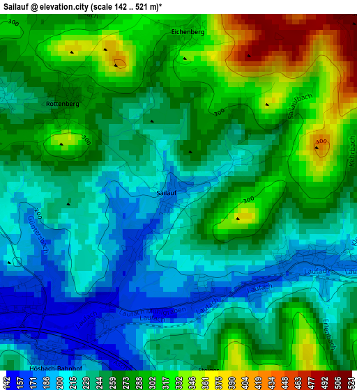
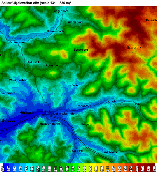
Below is the Elevation map of Sailauf, which displays elevation range with different colors. Scale of the first map is from 142 to 521 m (466 to 1709 ft) with average elevation of 259.7 meters (=852 ft) [note 1]
These maps also provides idea of topography and contour of this city, they are displayed at different zoom levels. More info about maps, scale and edge coordinates you can find below images.
| \ | Map #1 | Map #2 | Topo.Map |
| Scale [m] | 142..521 m | 131..536 m | × |
| Scale [ft] | 466..1709 ft | 430..1759 ft | × |
| Average | 259.7 m = 852 ft | 285.1 m = 935 ft | × |
| Width | 6.28 km = 3.9 mi | 12.56 km = 7.8 mi | 200.9 km = 124.8 mi |
| Height | 6.28 km = 3.9 mi | 12.56 km = 7.8 mi | 200.9 km = 124.8 mi |
| ↑Max Latitude | 50.052835° | 50.081043° | 50.91959° |
| Latitude at center | 50.02461° | 50.02461° | 50.02461° |
| ↓Min Latitude | 49.996369° | 49.968111° | 49.11264° |
| ← Min Longitude | 9.215375° | 9.171429° | 7.85307° |
| Longitude center | 9.25932° | 9.25932° | 9.25932° |
| →Max Longitude | 9.303265° | 9.347211° | 10.66557° |
Nearby cities:
Cities around Sailauf sort by population:
• Hösbach elevation 160 m
4.2 km,  241°
241°
• Goldbach 144 m
6 km, 242°
• Haibach 279 m
7.7 km,  209°
209°
• Laufach 200 m
3 km,  106°
106°
• Waldaschaff 220 m
6.3 km,  150°
150°
• Johannesberg 342 m
8.4 km,  275°
275°
• Schöllkrippen 209 m
6.8 km,  352°
352°
• Glattbach 197 m
8.3 km,  250°
250°
• Heigenbrücken 294 m
8 km,  87°
87°
• Krombach 249 m
7.5 km,  329°
329°
• Blankenbach 191 m
5 km,  338°
338°
• Sommerkahl 216 m
5 km,  357°
357°
Multilingual:
 En español:
Sailauf elevación 182 m.
 En France:
Sailauf élévation 182 m.


Sources and notes:
- [note 1] Map square and city borders are not equal. Map elevation data is calculated only from area inside that square.
- [src 1] Elevation data from geonames database provided with same terms of usage.
- [src 2] The elevation map of Sailauf is generated using elevation data from NASA's 3 arcsec (90m) resolution SRTM data.
- [src 3] Base (background) map © OpenStreetMap contributors tiles are generated by Geofabrik and OpenTopoMap.
Copyright & License:
This Sailauf Elevation Map is licensed under CC BY-SA. You may reuse any part from this page, if you give a proper credit by linking to this URL:
 More info on terms of use page.