Sankt Katharinen elevation
Sankt Katharinen (Rheinland-Pfalz), Germany elevation is 298 meters and Sankt Katharinen elevation in feet is 978 ft above sea level [src 1]. Sankt Katharinen is a populated place (feature code) with elevation that is 40 meters (131 ft) bigger than average city elevation in Germany.
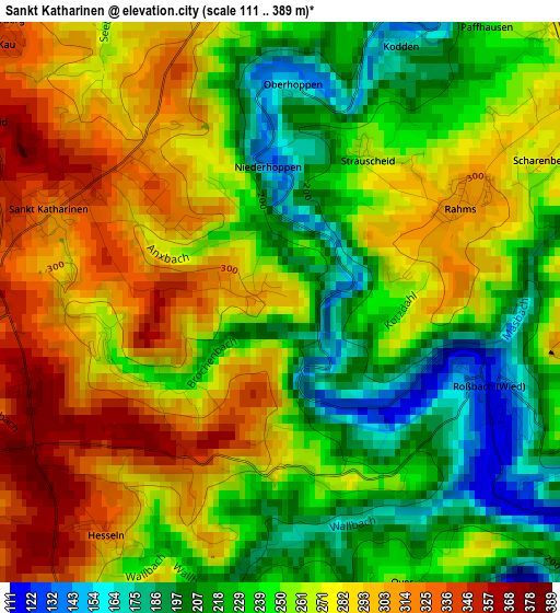
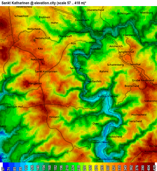
Below is the Elevation map of Sankt Katharinen, which displays elevation range with different colors. Scale of the first map is from 111 to 389 m (364 to 1276 ft) with average elevation of 259.3 meters (=851 ft) [note 1]
These maps also provides idea of topography and contour of this city, they are displayed at different zoom levels. More info about maps, scale and edge coordinates you can find below images.
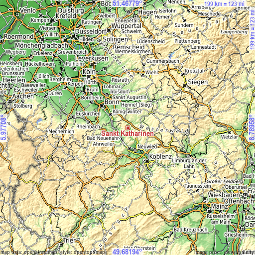
| \ | Map #1 | Map #2 | Topo.Map |
| Scale [m] | 111..389 m | 57..418 m | × |
| Scale [ft] | 364..1276 ft | 187..1371 ft | × |
| Average | 259.3 m = 851 ft | 260.3 m = 854 ft | × |
| Width | 6.21 km = 3.9 mi | 12.41 km = 7.7 mi | 198.6 km = 123.4 mi |
| Height | 6.21 km = 3.9 mi | 12.41 km = 7.7 mi | 198.6 km = 123.4 mi |
| ↑Max Latitude | 50.611225° | 50.639104° | 51.46779° |
| Latitude at center | 50.58333° | 50.58333° | 50.58333° |
| ↓Min Latitude | 50.555418° | 50.52749° | 49.68194° |
| ← Min Longitude | 7.339385° | 7.295439° | 5.97708° |
| Longitude center | 7.38333° | 7.38333° | 7.38333° |
| →Max Longitude | 7.427275° | 7.471221° | 8.78958° |
Nearby cities:
Cities around Sankt Katharinen sort by population:
• Asbach elevation 249 m
9.6 km,  14°
14°
• Linz am Rhein 75 m
7.2 km,  257°
257°
• Bad Hönningen 69 m
8.9 km,  214°
214°
• Windhagen 315 m
6.8 km,  341°
341°
• Vettelschoß 281 m
4.4 km,  327°
327°
• Hausen 128 m
4.8 km,  159°
159°
• Waldbreitbach 114 m
4.4 km,  147°
147°
• Leubsdorf 133 m
7 km,  237°
237°
• Dattenberg 182 m
7.1 km, 242°
• Niederbreitbach 130 m
6.4 km, 155°
• Kasbach-Ohlenberg 168 m
8.2 km,  270°
270°
• Ockenfels 124 m
7.7 km, 263°
Multilingual:
 En español:
Sankt Katharinen elevación 298 m.
 En France:
Sankt Katharinen élévation 298 m.
 Auf Deutsch:
Sankt Katharinen höhe über dem Meeresspiegel ist 298 m.

Sources and notes:
- [note 1] Map square and city borders are not equal. Map elevation data is calculated only from area inside that square.
- [src 1] Elevation data from geonames database provided with same terms of usage.
- [src 2] The elevation map of Sankt Katharinen is generated using elevation data from NASA's 3 arcsec (90m) resolution SRTM data.
- [src 3] Base (background) map © OpenStreetMap contributors tiles are generated by Geofabrik and OpenTopoMap.
Copyright & License:
This Sankt Katharinen Elevation Map is licensed under CC BY-SA. You may reuse any part from this page, if you give a proper credit by linking to this URL:
 More info on terms of use page.