Osann-Monzel elevation
Osann-Monzel (Rheinland-Pfalz), Germany elevation is 175 meters and Osann-Monzel elevation in feet is 574 ft above sea level [src 1]. Osann-Monzel is a seat of a fourth-order administrative division (feature code) with elevation that is 83 meters (272 ft) smaller than average city elevation in Germany.
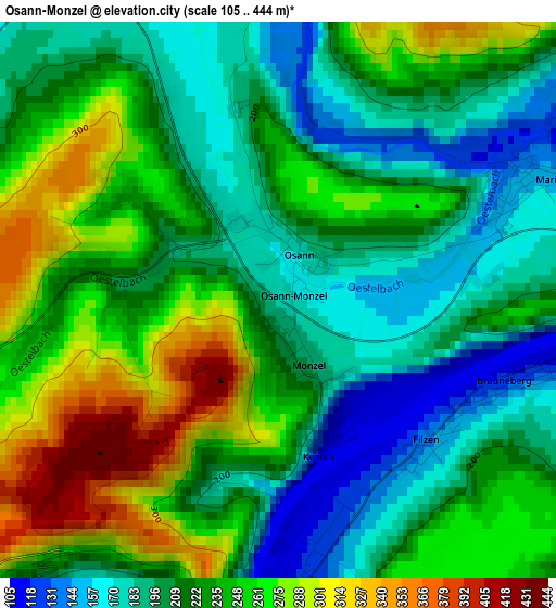
Below is the Elevation map of Osann-Monzel, which displays elevation range with different colors. Scale of the first map is from 105 to 444 m (344 to 1457 ft) with average elevation of 227.4 meters (=746 ft) [note 1]
These maps also provides idea of topography and contour of this city, they are displayed at different zoom levels. More info about maps, scale and edge coordinates you can find below images.
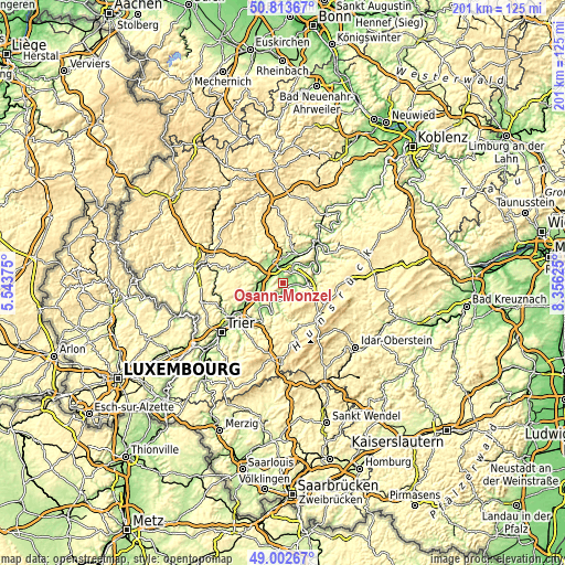
| \ | Map #1 | Topo.Map |
| Scale [m] | 105..444 m | × |
| Scale [ft] | 344..1457 ft | × |
| Average | 227.4 m = 746 ft | × |
| Width | 6.29 km = 3.9 mi | 201.4 km = 125.1 mi |
| Height | 6.29 km = 3.9 mi | 201.3 km = 125.1 mi |
| ↑Max Latitude | 49.944958° | 50.81367° |
| Latitude at center | 49.91667° | 49.91667° |
| ↓Min Latitude | 49.888365° | 49.00267° |
| ← Min Longitude | 6.906055° | 5.54375° |
| Longitude center | 6.95° | 6.95° |
| →Max Longitude | 6.993945° | 8.35625° |
Nearby cities:
Cities around Osann-Monzel sort by population:
• Wittlich elevation 178 m
8.7 km,  332°
332°
• Bernkastel-Kues 119 m
9.1 km,  90°
90°
• Neumagen-Dhron 137 m
7.8 km,  208°
208°
• Zeltingen-Rachtig 106 m
6 km,  52°
52°
• Salmtal 184 m
7.4 km,  284°
284°
• Piesport 124 m
4.1 km,  215°
215°
• Altrich 185 m
5.2 km, 328°
• Maring-Noviand 186 m
4 km,  62°
62°
• Klausen 276 m
5.1 km,  248°
248°
• Monzelfeld 443 m
9.2 km,  107°
107°
• Lieser 112 m
4.8 km, 90°
• Brauneberg 142 m
2.5 km,  118°
118°
Multilingual:
 En español:
Osann-Monzel elevación 175 m.
 En France:
Osann-Monzel élévation 175 m.
 Auf Deutsch:
Osann-Monzel höhe über dem Meeresspiegel ist 175 m.

Sources and notes:
- [note 1] Map square and city borders are not equal. Map elevation data is calculated only from area inside that square.
- [src 1] Elevation data from geonames database provided with same terms of usage.
- [src 2] The elevation map of Osann-Monzel is generated using elevation data from NASA's 3 arcsec (90m) resolution SRTM data.
- [src 3] Base (background) map © OpenStreetMap contributors tiles are generated by Geofabrik and OpenTopoMap.
Copyright & License:
This Osann-Monzel Elevation Map is licensed under CC BY-SA. You may reuse any part from this page, if you give a proper credit by linking to this URL:
 More info on terms of use page.