Hoppstädten-Weiersbach elevation
Hoppstädten-Weiersbach (Rheinland-Pfalz), Germany elevation is 336 meters and Hoppstädten-Weiersbach elevation in feet is 1102 ft above sea level [src 1]. Hoppstädten-Weiersbach is a seat of a fourth-order administrative division (feature code) with elevation that is 78 meters (256 ft) bigger than average city elevation in Germany.
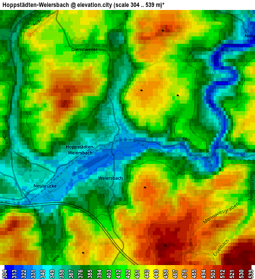
Below is the Elevation map of Hoppstädten-Weiersbach, which displays elevation range with different colors. Scale of the first map is from 304 to 539 m (997 to 1768 ft) with average elevation of 414.2 meters (=1359 ft) [note 1]
These maps also provides idea of topography and contour of this city, they are displayed at different zoom levels. More info about maps, scale and edge coordinates you can find below images.
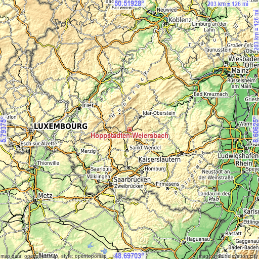
| \ | Map #1 | Topo.Map |
| Scale [m] | 304..539 m | × |
| Scale [ft] | 997..1768 ft | × |
| Average | 414.2 m = 1359 ft | × |
| Width | 6.33 km = 3.9 mi | 202.6 km = 125.9 mi |
| Height | 6.33 km = 3.9 mi | 202.6 km = 125.9 mi |
| ↑Max Latitude | 49.645134° | 50.51928° |
| Latitude at center | 49.61667° | 49.61667° |
| ↓Min Latitude | 49.58819° | 48.69703° |
| ← Min Longitude | 7.156055° | 5.79375° |
| Longitude center | 7.2° | 7.2° |
| →Max Longitude | 7.243945° | 8.60625° |
Nearby cities:
Cities around Hoppstädten-Weiersbach sort by population:
• Idar-Oberstein elevation 288 m
13.4 km,  35°
35°
• Sankt Wendel 280 m
16.9 km,  187°
187°
• Nohfelden 351 m
5.3 km,  231°
231°
• Nonnweiler 397 m
16.6 km,  266°
266°
• Freisen 460 m
8.2 km,  154°
154°
• Namborn 340 m
11.4 km,  202°
202°
• Birkenfeld 402 m
4.6 km,  328°
328°
• Oberthal 318 m
14.3 km,  215°
215°
• Baumholder 466 m
9.6 km,  89°
89°
• Brücken 391 m
6.3 km,  287°
287°
• Kirschweiler 485 m
15.3 km,  13°
13°
• Pfeffelbach 314 m
12.6 km,  132°
132°
Multilingual:
 En español:
Hoppstädten-Weiersbach elevación 336 m.
 En France:
Hoppstädten-Weiersbach élévation 336 m.
 Auf Deutsch:
Hoppstädten-Weiersbach höhe über dem Meeresspiegel ist 336 m.
 На русском:
Хопштедтен-Вайерсбах высота над уровнем моря 336 м
Sources and notes:
- [note 1] Map square and city borders are not equal. Map elevation data is calculated only from area inside that square.
- [src 1] Elevation data from geonames database provided with same terms of usage.
- [src 2] The elevation map of Hoppstädten-Weiersbach is generated using elevation data from NASA's 3 arcsec (90m) resolution SRTM data.
- [src 3] Base (background) map © OpenStreetMap contributors tiles are generated by Geofabrik and OpenTopoMap.
Copyright & License:
This Hoppstädten-Weiersbach Elevation Map is licensed under CC BY-SA. You may reuse any part from this page, if you give a proper credit by linking to this URL:
 More info on terms of use page.