Aach elevation
Aach (Baden-Württemberg, Freiburg Region), Germany elevation is 481 meters and Aach elevation in feet is 1578 ft above sea level [src 1]. Aach is a populated place (feature code) with elevation that is 223 meters (732 ft) bigger than average city elevation in Germany.
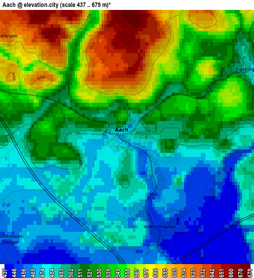
Below is the Elevation map of Aach, which displays elevation range with different colors. Scale of the first map is from 437 to 679 m (1434 to 2228 ft) with average elevation of 516.9 meters (=1696 ft) [note 1]
These maps also provides idea of topography and contour of this city, they are displayed at different zoom levels. More info about maps, scale and edge coordinates you can find below images.
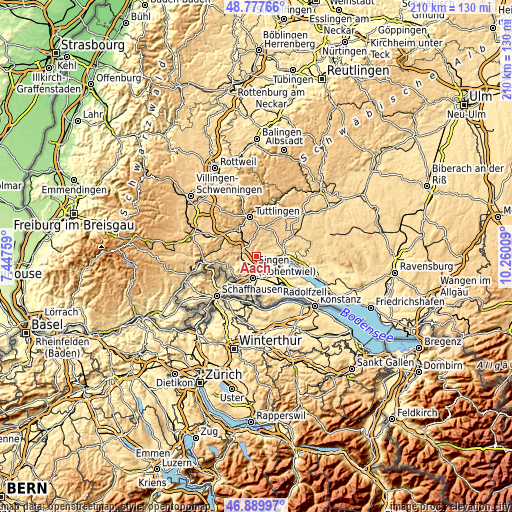
| \ | Map #1 | Topo.Map |
| Scale [m] | 437..679 m | × |
| Scale [ft] | 1434..2228 ft | × |
| Average | 516.9 m = 1696 ft | × |
| Width | 6.56 km = 4.1 mi | 209.9 km = 130.4 mi |
| Height | 6.56 km = 4.1 mi | 209.9 km = 130.4 mi |
| ↑Max Latitude | 47.871886° | 48.77766° |
| Latitude at center | 47.8424° | 47.8424° |
| ↓Min Latitude | 47.812897° | 46.88997° |
| ← Min Longitude | 8.809895° | 7.44759° |
| Longitude center | 8.85384° | 8.85384° |
| →Max Longitude | 8.897785° | 10.26009° |
Nearby cities:
Cities around Aach sort by population:
• Singen elevation 436 m
9.3 km,  186°
186°
• Stockach 474 m
11.6 km,  85°
85°
• Rielasingen-Worblingen 421 m
12 km,  184°
184°
• Engen 530 m
6.2 km,  283°
283°
• Hilzingen 468 m
9.9 km,  212°
212°
• Emmingen-Liptingen 742 m
10.3 km,  12°
12°
• Steißlingen 465 m
7.6 km,  128°
128°
• Neuhausen 496 m
5.9 km,  264°
264°
• Mühlhausen-Ehingen 455 m
4.7 km,  221°
221°
• Eigeltingen 482 m
3.7 km,  62°
62°
• Orsingen-Nenzingen 460 m
7.9 km, 89°
• Volkertshausen 445 m
3 km,  161°
161°
Multilingual:
 En español:
Aach elevación 481 m.
 En France:
Aach élévation 481 m.


Sources and notes:
- [note 1] Map square and city borders are not equal. Map elevation data is calculated only from area inside that square.
- [src 1] Elevation data from geonames database provided with same terms of usage.
- [src 2] The elevation map of Aach is generated using elevation data from NASA's 3 arcsec (90m) resolution SRTM data.
- [src 3] Base (background) map © OpenStreetMap contributors tiles are generated by Geofabrik and OpenTopoMap.
Copyright & License:
This Aach Elevation Map is licensed under CC BY-SA. You may reuse any part from this page, if you give a proper credit by linking to this URL:
 More info on terms of use page.