Altkirchen elevation
Altkirchen (Thuringia), Germany elevation is 224 meters and Altkirchen elevation in feet is 735 ft above sea level [src 1]. Altkirchen is a seat of a fourth-order administrative division (feature code) with elevation that is 34 meters (112 ft) smaller than average city elevation in Germany.
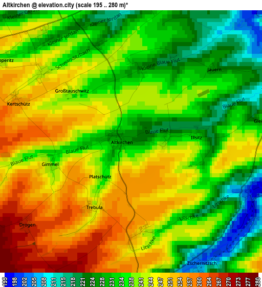
Below is the Elevation map of Altkirchen, which displays elevation range with different colors. Scale of the first map is from 195 to 280 m (640 to 919 ft) with average elevation of 239.4 meters (=785 ft) [note 1]
These maps also provides idea of topography and contour of this city, they are displayed at different zoom levels. More info about maps, scale and edge coordinates you can find below images.
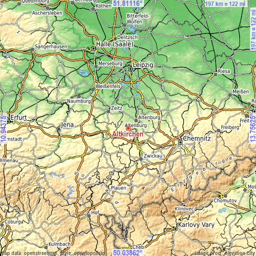
| \ | Map #1 | Topo.Map |
| Scale [m] | 195..280 m | × |
| Scale [ft] | 640..919 ft | × |
| Average | 239.4 m = 785 ft | × |
| Width | 6.16 km = 3.8 mi | 197.1 km = 122.5 mi |
| Height | 6.16 km = 3.8 mi | 197.1 km = 122.5 mi |
| ↑Max Latitude | 50.961017° | 51.81116° |
| Latitude at center | 50.93333° | 50.93333° |
| ↓Min Latitude | 50.905626° | 50.03862° |
| ← Min Longitude | 12.306055° | 10.94375° |
| Longitude center | 12.35° | 12.35° |
| →Max Longitude | 12.393945° | 13.75625° |
Nearby cities:
Cities around Altkirchen sort by population:
• Altenburg elevation 193 m
8.6 km,  45°
45°
• Schmölln 211 m
4.1 km,  176°
176°
• Gößnitz 209 m
7.6 km,  130°
130°
• Nobitz 182 m
10.7 km,  63°
63°
• Rositz 193 m
9.4 km,  5°
5°
• Saara 191 m
5 km,  90°
90°
• Ponitz 220 m
9.9 km,  148°
148°
• Kayna 217 m
10.4 km,  310°
310°
• Pölzig 285 m
10.7 km,  280°
280°
• Löbichau 237 m
7.5 km,  234°
234°
• Kriebitzsch 203 m
10.1 km,  353°
353°
• Nöbdenitz 275 m
8.8 km,  212°
212°
Multilingual:
 En español:
Altkirchen elevación 224 m.
 En France:
Altkirchen élévation 224 m.
 Auf Deutsch:
Altkirchen höhe über dem Meeresspiegel ist 224 m.

Sources and notes:
- [note 1] Map square and city borders are not equal. Map elevation data is calculated only from area inside that square.
- [src 1] Elevation data from geonames database provided with same terms of usage.
- [src 2] The elevation map of Altkirchen is generated using elevation data from NASA's 3 arcsec (90m) resolution SRTM data.
- [src 3] Base (background) map © OpenStreetMap contributors tiles are generated by Geofabrik and OpenTopoMap.
Copyright & License:
This Altkirchen Elevation Map is licensed under CC BY-SA. You may reuse any part from this page, if you give a proper credit by linking to this URL:
 More info on terms of use page.