Alt Meteln elevation
Alt Meteln (Mecklenburg-Vorpommern), Germany elevation is 53 meters and Alt Meteln elevation in feet is 174 ft above sea level [src 1]. Alt Meteln is a populated place (feature code) with elevation that is 205 meters (673 ft) smaller than average city elevation in Germany.
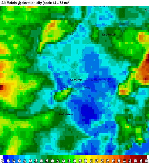
Below is the Elevation map of Alt Meteln, which displays elevation range with different colors. Scale of the first map is from 44 to 88 m (144 to 289 ft) with average elevation of 57.3 meters (=188 ft) [note 1]
These maps also provides idea of topography and contour of this city, they are displayed at different zoom levels. More info about maps, scale and edge coordinates you can find below images.
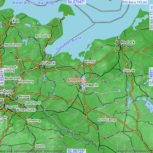
| \ | Map #1 | Topo.Map |
| Scale [m] | 44..88 m | × |
| Scale [ft] | 144..289 ft | × |
| Average | 57.3 m = 188 ft | × |
| Width | 5.78 km = 3.6 mi | 184.9 km = 114.9 mi |
| Height | 5.78 km = 3.6 mi | 184.9 km = 114.9 mi |
| ↑Max Latitude | 53.773069° | 54.57047° |
| Latitude at center | 53.74709° | 53.74709° |
| ↓Min Latitude | 53.721095° | 52.90725° |
| ← Min Longitude | 11.296615° | 9.93431° |
| Longitude center | 11.34056° | 11.34056° |
| →Max Longitude | 11.384505° | 12.74681° |
Nearby cities:
Cities around Alt Meteln sort by population:
• Weststadt elevation 65 m
13 km,  163°
163°
• Lankow 51 m
11 km,  170°
170°
• Bad Kleinen 55 m
9 km,  72°
72°
• Wittenförden 67 m
13.1 km,  183°
183°
• Neumühle 75 m
13 km, 171°
• Brüsewitz 54 m
10.2 km,  218°
218°
• Lewenberg 53 m
12.1 km, 158°
• Lübstorf 50 m
5.4 km,  116°
116°
• Bobitz 60 m
6.5 km,  10°
10°
• Retgendorf 46 m
10.9 km,  100°
100°
• Mühlen Eichsen 49 m
6.1 km,  281°
281°
• Seehof 51 m
8.6 km,  135°
135°
Multilingual:
 En español:
Alt Meteln elevación 53 m.
 En France:
Alt Meteln élévation 53 m.
 Auf Deutsch:
Alt Meteln höhe über dem Meeresspiegel ist 53 m.

Sources and notes:
- [note 1] Map square and city borders are not equal. Map elevation data is calculated only from area inside that square.
- [src 1] Elevation data from geonames database provided with same terms of usage.
- [src 2] The elevation map of Alt Meteln is generated using elevation data from NASA's 3 arcsec (90m) resolution SRTM data.
- [src 3] Base (background) map © OpenStreetMap contributors tiles are generated by Geofabrik and OpenTopoMap.
Copyright & License:
This Alt Meteln Elevation Map is licensed under CC BY-SA. You may reuse any part from this page, if you give a proper credit by linking to this URL:
 More info on terms of use page.