Altötting elevation
Altötting (Bavaria, Upper Bavaria), Germany elevation is 406 meters and Altötting elevation in feet is 1332 ft above sea level [src 1]. Altötting is a seat of a third-order administrative division (feature code) with elevation that is 148 meters (486 ft) bigger than average city elevation in Germany.
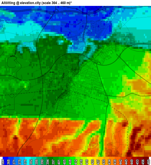
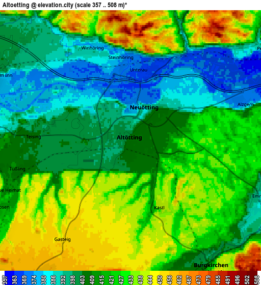
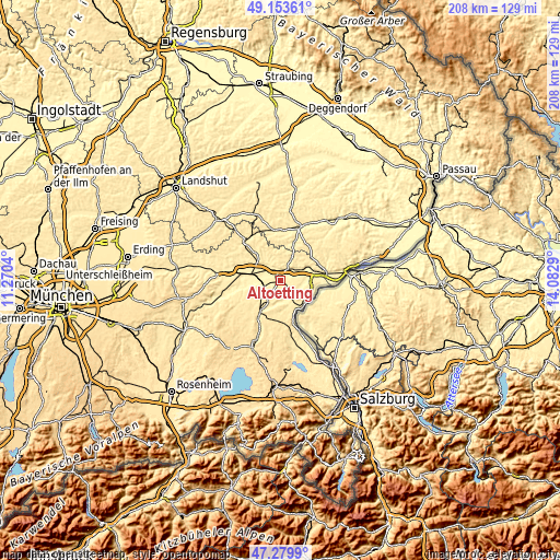
Below is the Elevation map of Altötting, which displays elevation range with different colors. Scale of the first map is from 364 to 460 m (1194 to 1509 ft) with average elevation of 405.5 meters (=1330 ft) [note 1]
These maps also provides idea of topography and contour of this city, they are displayed at different zoom levels. More info about maps, scale and edge coordinates you can find below images.
| \ | Map #1 | Map #2 | Topo.Map |
| Scale [m] | 364..460 m | 357..508 m | × |
| Scale [ft] | 1194..1509 ft | 1171..1667 ft | × |
| Average | 405.5 m = 1330 ft | 416.2 m = 1365 ft | × |
| Width | 6.51 km = 4 mi | 13.02 km = 8.1 mi | 208.3 km = 129.4 mi |
| Height | 6.51 km = 4 mi | 13.02 km = 8.1 mi | 208.3 km = 129.4 mi |
| ↑Max Latitude | 48.254598° | 48.283849° | 49.15361° |
| Latitude at center | 48.22533° | 48.22533° | 48.22533° |
| ↓Min Latitude | 48.196045° | 48.166744° | 47.2799° |
| ← Min Longitude | 12.632705° | 12.588759° | 11.2704° |
| Longitude center | 12.67665° | 12.67665° | 12.67665° |
| →Max Longitude | 12.720595° | 12.764541° | 14.0829° |
Nearby cities:
Cities around Altötting sort by population:
• Burgkirchen an der Alz elevation 428 m
7.6 km,  147°
147°
• Töging am Inn 401 m
7.8 km,  299°
299°
• Neuötting 389 m
2 km,  29°
29°
• Winhöring 385 m
5 km,  336°
336°
• Polling 408 m
8.2 km,  263°
263°
• Tüßling 412 m
5.9 km, 255°
• Unterneukirchen 459 m
7.9 km,  214°
214°
• Aresing 397 m
7.8 km,  317°
317°
• Kastl 438 m
3.3 km, 148°
• Reischach 418 m
8.1 km, 26°
• Teising 405 m
4.8 km,  272°
272°
• Perach 387 m
8.1 km,  55°
55°
Multilingual:
 En español:
Altötting elevación 406 m.
 En France:
Altötting élévation 406 m.
 Auf Deutsch:
Altötting höhe über dem Meeresspiegel ist 406 m.

Sources and notes:
- [note 1] Map square and city borders are not equal. Map elevation data is calculated only from area inside that square.
- [src 1] Elevation data from geonames database provided with same terms of usage.
- [src 2] The elevation map of Altötting is generated using elevation data from NASA's 3 arcsec (90m) resolution SRTM data.
- [src 3] Base (background) map © OpenStreetMap contributors tiles are generated by Geofabrik and OpenTopoMap.
Copyright & License:
This Altötting Elevation Map is licensed under CC BY-SA. You may reuse any part from this page, if you give a proper credit by linking to this URL:
 More info on terms of use page.