Atzendorf elevation
Atzendorf (Saxony-Anhalt), Germany elevation is 84 meters and Atzendorf elevation in feet is 276 ft above sea level [src 1]. Atzendorf is a populated place (feature code) with elevation that is 174 meters (571 ft) smaller than average city elevation in Germany.
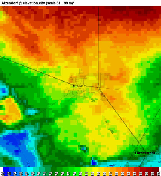
Below is the Elevation map of Atzendorf, which displays elevation range with different colors. Scale of the first map is from 61 to 99 m (200 to 325 ft) with average elevation of 82.6 meters (=271 ft) [note 1]
These maps also provides idea of topography and contour of this city, they are displayed at different zoom levels. More info about maps, scale and edge coordinates you can find below images.
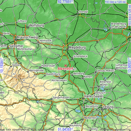
| \ | Map #1 | Topo.Map |
| Scale [m] | 61..99 m | × |
| Scale [ft] | 200..325 ft | × |
| Average | 82.6 m = 271 ft | × |
| Width | 6.03 km = 3.7 mi | 192.9 km = 119.9 mi |
| Height | 6.03 km = 3.7 mi | 192.9 km = 119.9 mi |
| ↑Max Latitude | 51.946636° | 52.77851° |
| Latitude at center | 51.91954° | 51.91954° |
| ↓Min Latitude | 51.892428° | 51.04381° |
| ← Min Longitude | 11.555115° | 10.19281° |
| Longitude center | 11.59906° | 11.59906° |
| →Max Longitude | 11.643005° | 13.00531° |
Nearby cities:
Cities around Atzendorf sort by population:
• Staßfurt elevation 67 m
7.6 km,  187°
187°
• Hecklingen 81 m
9.2 km,  208°
208°
• Biere 93 m
7.2 km,  31°
31°
• Förderstedt 77 m
3.4 km,  136°
136°
• Welsleben 77 m
9.7 km,  16°
16°
• Groß Börnecke 82 m
9.6 km,  246°
246°
• Wolmirsleben 79 m
8.6 km,  293°
293°
• Borne 91 m
4.3 km,  319°
319°
• Unseburg 70 m
6.1 km,  284°
284°
• Eickendorf 81 m
6.1 km,  59°
59°
• Glöthe 73 m
5.3 km,  101°
101°
• Brumby 71 m
8.5 km,  107°
107°
Multilingual:
 En español:
Atzendorf elevación 84 m.
 En France:
Atzendorf élévation 84 m.
 Auf Deutsch:
Atzendorf (Staßfurt) höhe über dem Meeresspiegel ist 84 m.

Sources and notes:
- [note 1] Map square and city borders are not equal. Map elevation data is calculated only from area inside that square.
- [src 1] Elevation data from geonames database provided with same terms of usage.
- [src 2] The elevation map of Atzendorf is generated using elevation data from NASA's 3 arcsec (90m) resolution SRTM data.
- [src 3] Base (background) map © OpenStreetMap contributors tiles are generated by Geofabrik and OpenTopoMap.
Copyright & License:
This Atzendorf Elevation Map is licensed under CC BY-SA. You may reuse any part from this page, if you give a proper credit by linking to this URL:
 More info on terms of use page.