Bad Sachsa elevation
Bad Sachsa (Lower Saxony), Germany elevation is 315 meters and Bad Sachsa elevation in feet is 1033 ft above sea level [src 1]. Bad Sachsa is a populated place (feature code) with elevation that is 57 meters (187 ft) bigger than average city elevation in Germany.
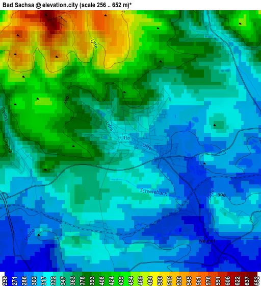
Below is the Elevation map of Bad Sachsa, which displays elevation range with different colors. Scale of the first map is from 256 to 652 m (840 to 2139 ft) with average elevation of 358.9 meters (=1177 ft) [note 1]
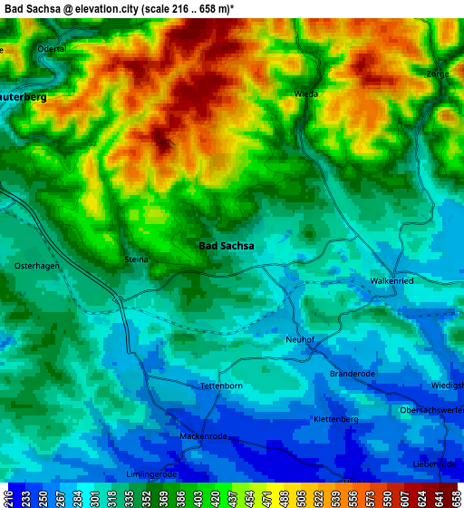
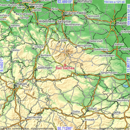
These maps also provides idea of topography and contour of this city, they are displayed at different zoom levels. More info about maps, scale and edge coordinates you can find below images.
| \ | Map #1 | Map #2 | Topo.Map |
| Scale [m] | 256..652 m | 216..658 m | × |
| Scale [ft] | 840..2139 ft | 709..2159 ft | × |
| Average | 358.9 m = 1177 ft | 360.4 m = 1182 ft | × |
| Width | 6.07 km = 3.8 mi | 12.14 km = 7.5 mi | 194.3 km = 120.7 mi |
| Height | 6.07 km = 3.8 mi | 12.14 km = 7.5 mi | 194.3 km = 120.7 mi |
| ↑Max Latitude | 51.622281° | 51.649556° | 52.46019° |
| Latitude at center | 51.59499° | 51.59499° | 51.59499° |
| ↓Min Latitude | 51.567682° | 51.540358° | 50.71298° |
| ← Min Longitude | 10.511515° | 10.467569° | 9.14921° |
| Longitude center | 10.55546° | 10.55546° | 10.55546° |
| →Max Longitude | 10.599405° | 10.643351° | 11.96171° |
Nearby cities:
Cities around Bad Sachsa sort by population:
• Bad Lauterberg im Harz elevation 304 m
7.2 km,  305°
305°
• Ellrich 255 m
7.5 km,  97°
97°
• Braunlage 563 m
15.1 km,  14°
14°
• Niedersachswerfen 214 m
15.4 km,  108°
108°
• Walkenried 271 m
4.4 km, 107°
• Benneckenstein 512 m
13.8 km,  53°
53°
• Bischofferode 299 m
13.4 km,  215°
215°
• Sankt Andreasberg 610 m
13 km,  348°
348°
• Großbodungen 272 m
14.2 km,  201°
201°
• Wieda 360 m
4.9 km,  26°
26°
• Weißenborn-Lüderode 242 m
11.8 km,  233°
233°
• Zorge 385 m
6.9 km, 51°
Multilingual:
 En español:
Bad Sachsa elevación 315 m.
 En France:
Bad Sachsa élévation 315 m.
 Auf Deutsch:
Bad Sachsa höhe über dem Meeresspiegel ist 315 m.

Sources and notes:
- [note 1] Map square and city borders are not equal. Map elevation data is calculated only from area inside that square.
- [src 1] Elevation data from geonames database provided with same terms of usage.
- [src 2] The elevation map of Bad Sachsa is generated using elevation data from NASA's 3 arcsec (90m) resolution SRTM data.
- [src 3] Base (background) map © OpenStreetMap contributors tiles are generated by Geofabrik and OpenTopoMap.
Copyright & License:
This Bad Sachsa Elevation Map is licensed under CC BY-SA. You may reuse any part from this page, if you give a proper credit by linking to this URL:
 More info on terms of use page.