Bad Schandau elevation
Bad Schandau (Saxony), Germany elevation is 127 meters and Bad Schandau elevation in feet is 417 ft above sea level [src 1]. Bad Schandau is a populated place (feature code) with elevation that is 131 meters (430 ft) smaller than average city elevation in Germany.
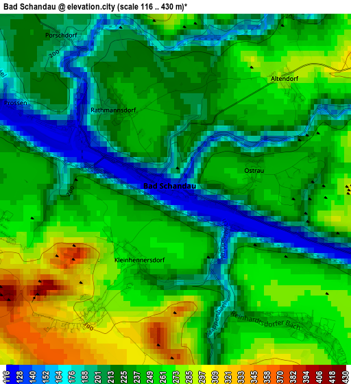
Below is the Elevation map of Bad Schandau, which displays elevation range with different colors. Scale of the first map is from 116 to 430 m (381 to 1411 ft) with average elevation of 237.4 meters (=779 ft) [note 1]
These maps also provides idea of topography and contour of this city, they are displayed at different zoom levels. More info about maps, scale and edge coordinates you can find below images.
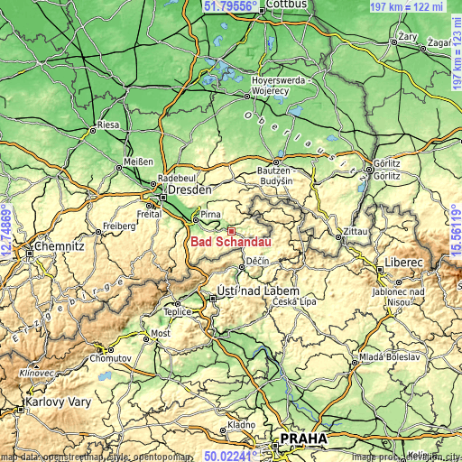
| \ | Map #1 | Topo.Map |
| Scale [m] | 116..430 m | × |
| Scale [ft] | 381..1411 ft | × |
| Average | 237.4 m = 779 ft | × |
| Width | 6.16 km = 3.8 mi | 197.2 km = 122.5 mi |
| Height | 6.16 km = 3.8 mi | 197.1 km = 122.5 mi |
| ↑Max Latitude | 50.945127° | 51.79556° |
| Latitude at center | 50.91743° | 50.91743° |
| ↓Min Latitude | 50.889717° | 50.02241° |
| ← Min Longitude | 14.110995° | 12.74869° |
| Longitude center | 14.15494° | 14.15494° |
| →Max Longitude | 14.198885° | 15.56119° |
Nearby cities:
Cities around Bad Schandau sort by population:
• Neustadt in Sachsen elevation 327 m
13.1 km,  19°
19°
• Sebnitz 319 m
10.6 km,  52°
52°
• Hohnstein 317 m
7.5 km,  337°
337°
• Lohmen 206 m
13.3 km,  306°
306°
• Königstein 127 m
5.8 km,  268°
268°
• Struppen 231 m
9.9 km,  280°
280°
• Kurort Gohrisch 258 m
3.4 km,  260°
260°
• Dohma 215 m
15.5 km, 269°
• Berthelsdorf 336 m
15.1 km, 18°
• Stadt Wehlen 163 m
9.8 km,  297°
297°
• Porschdorf 195 m
3.3 km,  324°
324°
• Rathmannsdorf 237 m
1.7 km,  327°
327°
Multilingual:
 En español:
Bad Schandau elevación 127 m.
 En France:
Bad Schandau élévation 127 m.
 Auf Deutsch:
Bad Schandau höhe über dem Meeresspiegel ist 127 m.

Sources and notes:
- [note 1] Map square and city borders are not equal. Map elevation data is calculated only from area inside that square.
- [src 1] Elevation data from geonames database provided with same terms of usage.
- [src 2] The elevation map of Bad Schandau is generated using elevation data from NASA's 3 arcsec (90m) resolution SRTM data.
- [src 3] Base (background) map © OpenStreetMap contributors tiles are generated by Geofabrik and OpenTopoMap.
Copyright & License:
This Bad Schandau Elevation Map is licensed under CC BY-SA. You may reuse any part from this page, if you give a proper credit by linking to this URL:
 More info on terms of use page.