Bann elevation
Bann (Rheinland-Pfalz), Germany elevation is 376 meters and Bann elevation in feet is 1234 ft above sea level [src 1]. Bann is a seat of a fourth-order administrative division (feature code) with elevation that is 118 meters (387 ft) bigger than average city elevation in Germany.
Below is the Elevation map of Bann, which displays elevation range with different colors. Scale of the first map is from 275 to 483 m (902 to 1585 ft) with average elevation of 385.7 meters (=1265 ft) [note 1]
These maps also provides idea of topography and contour of this city, they are displayed at different zoom levels. More info about maps, scale and edge coordinates you can find below images.
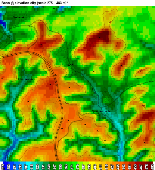
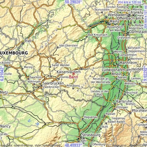
| \ | Map #1 | Topo.Map |
| Scale [m] | 275..483 m | × |
| Scale [ft] | 902..1585 ft | × |
| Average | 385.7 m = 1265 ft | × |
| Width | 6.36 km = 4 mi | 203.6 km = 126.5 mi |
| Height | 6.36 km = 4 mi | 203.6 km = 126.5 mi |
| ↑Max Latitude | 49.41193° | 50.29028° |
| Latitude at center | 49.38333° | 49.38333° |
| ↓Min Latitude | 49.354713° | 48.45933° |
| ← Min Longitude | 7.572725° | 6.21042° |
| Longitude center | 7.61667° | 7.61667° |
| →Max Longitude | 7.660615° | 9.02292° |
Nearby cities:
Cities around Bann sort by population:
• Landstuhl elevation 250 m
4.7 km,  314°
314°
• Ramstein-Miesenbach 242 m
8.1 km,  326°
326°
• Queidersbach 397 m
2.2 km,  146°
146°
• Kindsbach 255 m
3.7 km,  0°
0°
• Mackenbach 276 m
9.6 km,  345°
345°
• Obernheim-Kirchenarnbach 422 m
4.4 km,  213°
213°
• Hermersberg 408 m
7.5 km,  170°
170°
• Schopp 320 m
6.1 km,  127°
127°
• Weselberg 435 m
5.2 km,  187°
187°
• Stelzenberg 379 m
8.8 km,  94°
94°
• Linden 329 m
4.4 km, 146°
• Krickenbach 392 m
4.1 km,  117°
117°
Multilingual:
 En español:
Bann elevación 376 m.
 En France:
Bann élévation 376 m.


Sources and notes:
- [note 1] Map square and city borders are not equal. Map elevation data is calculated only from area inside that square.
- [src 1] Elevation data from geonames database provided with same terms of usage.
- [src 2] The elevation map of Bann is generated using elevation data from NASA's 3 arcsec (90m) resolution SRTM data.
- [src 3] Base (background) map © OpenStreetMap contributors tiles are generated by Geofabrik and OpenTopoMap.
Copyright & License:
This Bann Elevation Map is licensed under CC BY-SA. You may reuse any part from this page, if you give a proper credit by linking to this URL:
 More info on terms of use page.