Borrentin elevation
Borrentin (Mecklenburg-Vorpommern), Germany elevation is 42 meters and Borrentin elevation in feet is 138 ft above sea level [src 1]. Borrentin is a populated place (feature code) with elevation that is 216 meters (709 ft) smaller than average city elevation in Germany.
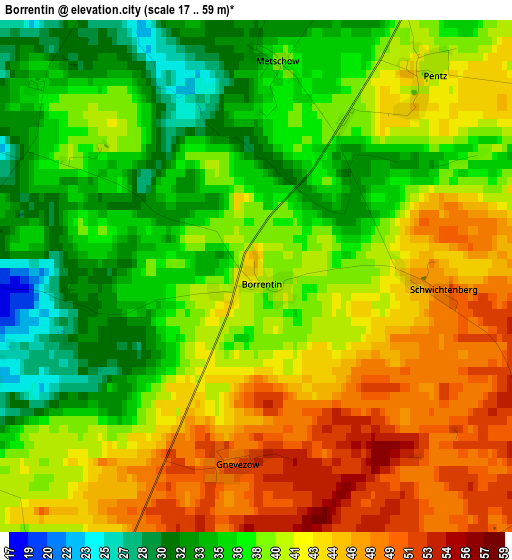
Below is the Elevation map of Borrentin, which displays elevation range with different colors. Scale of the first map is from 17 to 59 m (56 to 194 ft) with average elevation of 39.7 meters (=130 ft) [note 1]
These maps also provides idea of topography and contour of this city, they are displayed at different zoom levels. More info about maps, scale and edge coordinates you can find below images.
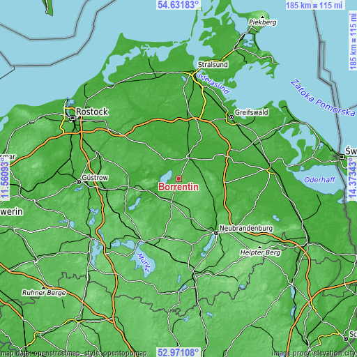
| \ | Map #1 | Topo.Map |
| Scale [m] | 17..59 m | × |
| Scale [ft] | 56..194 ft | × |
| Average | 39.7 m = 130 ft | × |
| Width | 5.77 km = 3.6 mi | 184.7 km = 114.8 mi |
| Height | 5.77 km = 3.6 mi | 184.6 km = 114.7 mi |
| ↑Max Latitude | 53.83562° | 54.63183° |
| Latitude at center | 53.80968° | 53.80968° |
| ↓Min Latitude | 53.783724° | 52.97108° |
| ← Min Longitude | 12.923235° | 11.56093° |
| Longitude center | 12.96718° | 12.96718° |
| →Max Longitude | 13.011125° | 14.37343° |
Nearby cities:
Cities around Borrentin sort by population:
• Demmin elevation 9 m
11.7 km,  21°
21°
• Malchin 10 m
15.4 km,  239°
239°
• Altentreptow 21 m
23.4 km,  123°
123°
• Dargun 19 m
12.7 km,  322°
322°
• Gützkow 82 m
13.2 km,  136°
136°
• Neukalen 7 m
11.7 km,  277°
277°
• Gielow 18 m
19.2 km,  229°
229°
• Wackerow 74 m
14.8 km,  176°
176°
• Tutow 11 m
21.9 km,  57°
57°
• Burow 40 m
20.5 km,  101°
101°
• Rosenow 71 m
20.6 km,  166°
166°
• Reinberg 49 m
19 km, 142°
Multilingual:
 En español:
Borrentin elevación 42 m.
 En France:
Borrentin élévation 42 m.
 Auf Deutsch:
Borrentin höhe über dem Meeresspiegel ist 42 m.

Sources and notes:
- [note 1] Map square and city borders are not equal. Map elevation data is calculated only from area inside that square.
- [src 1] Elevation data from geonames database provided with same terms of usage.
- [src 2] The elevation map of Borrentin is generated using elevation data from NASA's 3 arcsec (90m) resolution SRTM data.
- [src 3] Base (background) map © OpenStreetMap contributors tiles are generated by Geofabrik and OpenTopoMap.
Copyright & License:
This Borrentin Elevation Map is licensed under CC BY-SA. You may reuse any part from this page, if you give a proper credit by linking to this URL:
 More info on terms of use page.