Bramsche elevation
Bramsche (Lower Saxony), Germany elevation is 62 meters and Bramsche elevation in feet is 203 ft above sea level [src 1]. Bramsche is a populated place (feature code) with elevation that is 196 meters (643 ft) smaller than average city elevation in Germany.
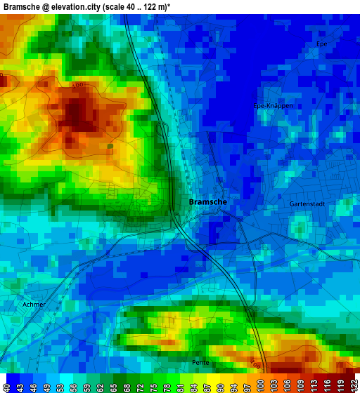
Below is the Elevation map of Bramsche, which displays elevation range with different colors. Scale of the first map is from 40 to 122 m (131 to 400 ft) with average elevation of 60.7 meters (=199 ft) [note 1]
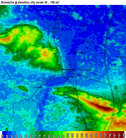
These maps also provides idea of topography and contour of this city, they are displayed at different zoom levels. More info about maps, scale and edge coordinates you can find below images.
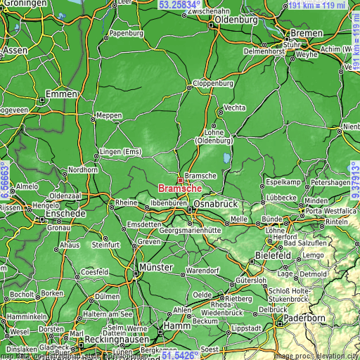
| \ | Map #1 | Map #2 | Topo.Map |
| Scale [m] | 40..122 m | 38..156 m | × |
| Scale [ft] | 131..400 ft | 125..512 ft | × |
| Average | 60.7 m = 199 ft | 60.9 m = 200 ft | × |
| Width | 5.96 km = 3.7 mi | 11.92 km = 7.4 mi | 190.8 km = 118.6 mi |
| Height | 5.96 km = 3.7 mi | 11.92 km = 7.4 mi | 190.8 km = 118.6 mi |
| ↑Max Latitude | 52.43561° | 52.462393° | 53.25834° |
| Latitude at center | 52.40881° | 52.40881° | 52.40881° |
| ↓Min Latitude | 52.381994° | 52.355162° | 51.5426° |
| ← Min Longitude | 7.928935° | 7.884989° | 6.56663° |
| Longitude center | 7.97288° | 7.97288° | 7.97288° |
| →Max Longitude | 8.016825° | 8.060771° | 9.37913° |
Nearby cities:
Cities around Bramsche sort by population:
• Osnabrück elevation 69 m
16 km,  160°
160°
• Wallenhorst 96 m
7.2 km, 155°
• Belm 90 m
16.3 km,  137°
137°
• Lotte 60 m
14.5 km,  195°
195°
• Mettingen 71 m
16.5 km,  231°
231°
• Westerkappeln 64 m
11.9 km,  210°
210°
• Bersenbrück 39 m
16 km,  354°
354°
• Merzen 102 m
12.6 km,  311°
311°
• Alfhausen 43 m
10.3 km, 351°
• Rieste 38 m
8.8 km,  19°
19°
• Neuenkirchen 41 m
12.9 km,  28°
28°
• Voltlage 46 m
15.4 km,  280°
280°
Multilingual:
 En español:
Bramsche elevación 62 m.
 En France:
Bramsche élévation 62 m.


Sources and notes:
- [note 1] Map square and city borders are not equal. Map elevation data is calculated only from area inside that square.
- [src 1] Elevation data from geonames database provided with same terms of usage.
- [src 2] The elevation map of Bramsche is generated using elevation data from NASA's 3 arcsec (90m) resolution SRTM data.
- [src 3] Base (background) map © OpenStreetMap contributors tiles are generated by Geofabrik and OpenTopoMap.
Copyright & License:
This Bramsche Elevation Map is licensed under CC BY-SA. You may reuse any part from this page, if you give a proper credit by linking to this URL:
 More info on terms of use page.