Brand-Erbisdorf elevation
Brand-Erbisdorf (Saxony), Germany elevation is 468 meters and Brand-Erbisdorf elevation in feet is 1535 ft above sea level [src 1]. Brand-Erbisdorf is a populated place (feature code) with elevation that is 210 meters (689 ft) bigger than average city elevation in Germany.
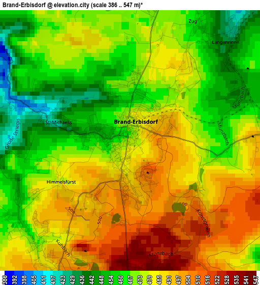
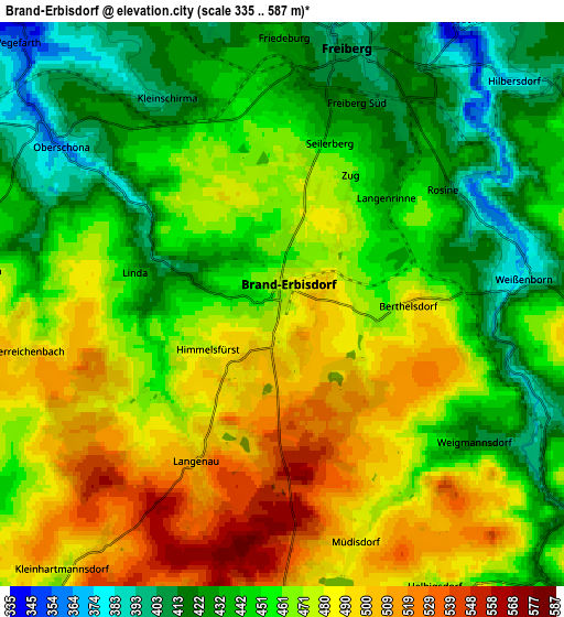
Below is the Elevation map of Brand-Erbisdorf, which displays elevation range with different colors. Scale of the first map is from 386 to 547 m (1266 to 1795 ft) with average elevation of 476.2 meters (=1562 ft) [note 1]
These maps also provides idea of topography and contour of this city, they are displayed at different zoom levels. More info about maps, scale and edge coordinates you can find below images.
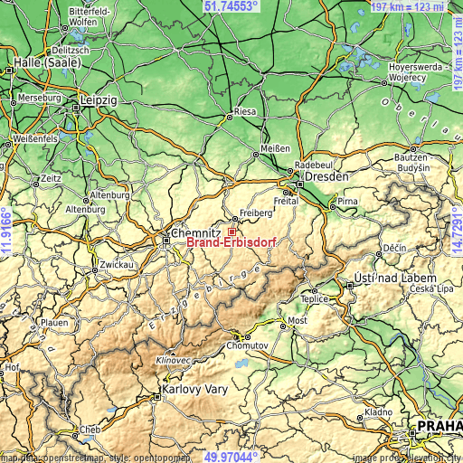
| \ | Map #1 | Map #2 | Topo.Map |
| Scale [m] | 386..547 m | 335..587 m | × |
| Scale [ft] | 1266..1795 ft | 1099..1926 ft | × |
| Average | 476.2 m = 1562 ft | 461.4 m = 1514 ft | × |
| Width | 6.17 km = 3.8 mi | 12.34 km = 7.7 mi | 197.4 km = 122.7 mi |
| Height | 6.17 km = 3.8 mi | 12.34 km = 7.7 mi | 197.4 km = 122.7 mi |
| ↑Max Latitude | 50.894157° | 50.921867° | 51.74553° |
| Latitude at center | 50.86643° | 50.86643° | 50.86643° |
| ↓Min Latitude | 50.838687° | 50.810927° | 49.97044° |
| ← Min Longitude | 13.278905° | 13.234959° | 11.9166° |
| Longitude center | 13.32285° | 13.32285° | 13.32285° |
| →Max Longitude | 13.366795° | 13.410741° | 14.7291° |
Nearby cities:
Cities around Brand-Erbisdorf sort by population:
• Freiberg elevation 412 m
5.1 km,  12°
12°
• Oederan 374 m
10.6 km,  266°
266°
• Großschirma 369 m
11.4 km,  346°
346°
• Eppendorf 452 m
9.7 km,  220°
220°
• Leubsdorf 407 m
13.2 km,  236°
236°
• Oberschöna 362 m
6 km,  305°
305°
• Halsbrücke 357 m
9.5 km, 11°
• Lichtenberg 415 m
8 km,  116°
116°
• Mulda 425 m
9.2 km,  135°
135°
• Großhartmannsdorf 506 m
7.4 km,  174°
174°
• Niederschöna 348 m
13 km,  31°
31°
• Frankenstein 375 m
8.8 km,  295°
295°
Multilingual:
 En español:
Brand-Erbisdorf elevación 468 m.
 En France:
Brand-Erbisdorf élévation 468 m.
 Auf Deutsch:
Brand-Erbisdorf höhe über dem Meeresspiegel ist 468 m.

Sources and notes:
- [note 1] Map square and city borders are not equal. Map elevation data is calculated only from area inside that square.
- [src 1] Elevation data from geonames database provided with same terms of usage.
- [src 2] The elevation map of Brand-Erbisdorf is generated using elevation data from NASA's 3 arcsec (90m) resolution SRTM data.
- [src 3] Base (background) map © OpenStreetMap contributors tiles are generated by Geofabrik and OpenTopoMap.
Copyright & License:
This Brand-Erbisdorf Elevation Map is licensed under CC BY-SA. You may reuse any part from this page, if you give a proper credit by linking to this URL:
 More info on terms of use page.