Clausen elevation
Clausen (Rheinland-Pfalz), Germany elevation is 402 meters and Clausen elevation in feet is 1319 ft above sea level [src 1]. Clausen is a seat of a fourth-order administrative division (feature code) with elevation that is 144 meters (472 ft) bigger than average city elevation in Germany.
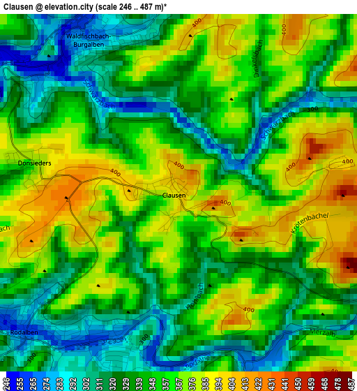
Below is the Elevation map of Clausen, which displays elevation range with different colors. Scale of the first map is from 246 to 487 m (807 to 1598 ft) with average elevation of 347.8 meters (=1141 ft) [note 1]
These maps also provides idea of topography and contour of this city, they are displayed at different zoom levels. More info about maps, scale and edge coordinates you can find below images.
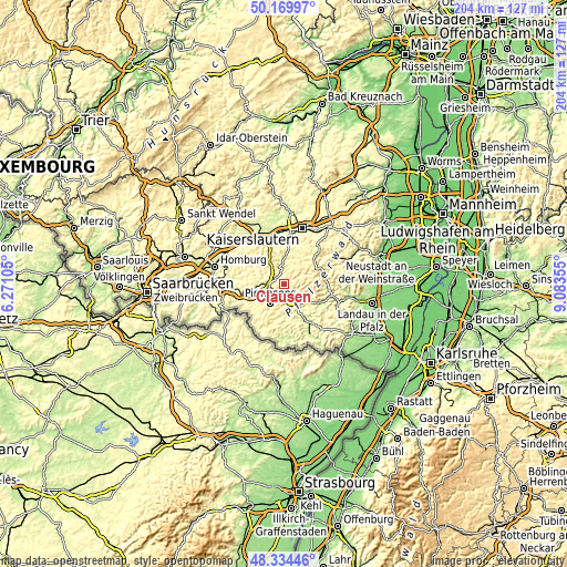
| \ | Map #1 | Topo.Map |
| Scale [m] | 246..487 m | × |
| Scale [ft] | 807..1598 ft | × |
| Average | 347.8 m = 1141 ft | × |
| Width | 6.38 km = 4 mi | 204.1 km = 126.8 mi |
| Height | 6.38 km = 4 mi | 204.1 km = 126.8 mi |
| ↑Max Latitude | 49.289421° | 50.16997° |
| Latitude at center | 49.26075° | 49.26075° |
| ↓Min Latitude | 49.232062° | 48.33446° |
| ← Min Longitude | 7.633355° | 6.27105° |
| Longitude center | 7.6773° | 7.6773° |
| →Max Longitude | 7.721245° | 9.08355° |
Nearby cities:
Cities around Clausen sort by population:
• Pirmasens elevation 400 m
8.4 km,  218°
218°
• Rodalben 267 m
3.6 km,  229°
229°
• Waldfischbach-Burgalben 352 m
2.6 km,  342°
342°
• Thaleischweiler-Fröschen 290 m
6.9 km,  275°
275°
• Münchweiler an der Rodalbe 279 m
5.1 km,  158°
158°
• Heltersberg 418 m
6.8 km,  24°
24°
• Hermersberg 408 m
7 km,  332°
332°
• Hinterweidenthal 224 m
8.6 km,  141°
141°
• Ruppertsweiler 294 m
7.1 km,  172°
172°
• Merzalben 288 m
4.3 km,  114°
114°
• Höheinöd 406 m
6 km,  302°
302°
• Höheischweiler 352 m
9.7 km,  251°
251°
Multilingual:
 En español:
Clausen elevación 402 m.
 En France:
Clausen élévation 402 m.


Sources and notes:
- [note 1] Map square and city borders are not equal. Map elevation data is calculated only from area inside that square.
- [src 1] Elevation data from geonames database provided with same terms of usage.
- [src 2] The elevation map of Clausen is generated using elevation data from NASA's 3 arcsec (90m) resolution SRTM data.
- [src 3] Base (background) map © OpenStreetMap contributors tiles are generated by Geofabrik and OpenTopoMap.
Copyright & License:
This Clausen Elevation Map is licensed under CC BY-SA. You may reuse any part from this page, if you give a proper credit by linking to this URL:
 More info on terms of use page.