Dausenau elevation
Dausenau (Rheinland-Pfalz), Germany elevation is 240 meters and Dausenau elevation in feet is 787 ft above sea level [src 1]. Dausenau is a seat of a fourth-order administrative division (feature code) with elevation that is 18 meters (59 ft) smaller than average city elevation in Germany.
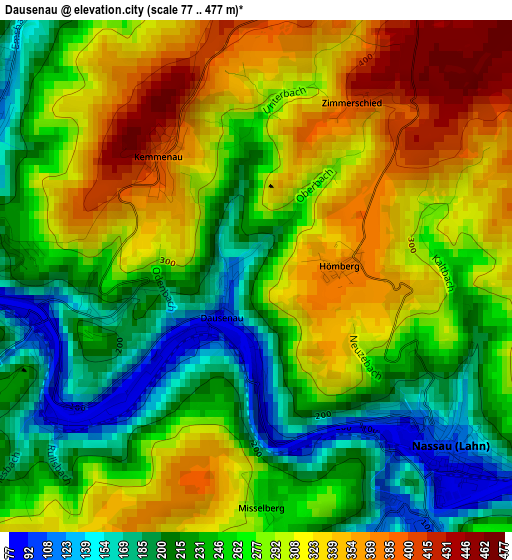
Below is the Elevation map of Dausenau, which displays elevation range with different colors. Scale of the first map is from 77 to 477 m (253 to 1565 ft) with average elevation of 272.7 meters (=895 ft) [note 1]
These maps also provides idea of topography and contour of this city, they are displayed at different zoom levels. More info about maps, scale and edge coordinates you can find below images.
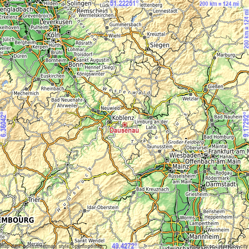
| \ | Map #1 | Topo.Map |
| Scale [m] | 77..477 m | × |
| Scale [ft] | 253..1565 ft | × |
| Average | 272.7 m = 895 ft | × |
| Width | 6.24 km = 3.9 mi | 199.6 km = 124 mi |
| Height | 6.24 km = 3.9 mi | 199.6 km = 124 mi |
| ↑Max Latitude | 50.361373° | 51.22251° |
| Latitude at center | 50.33333° | 50.33333° |
| ↓Min Latitude | 50.305271° | 49.4272° |
| ← Min Longitude | 7.722725° | 6.36042° |
| Longitude center | 7.76667° | 7.76667° |
| →Max Longitude | 7.810615° | 9.17292° |
Nearby cities:
Cities around Dausenau sort by population:
• Bad Ems elevation 86 m
3.8 km,  273°
273°
• Nassau 102 m
3.2 km,  131°
131°
• Eitelborn 280 m
5.8 km,  328°
328°
• Neuhäusel 323 m
6.9 km,  324°
324°
• Singhofen 301 m
8.1 km,  144°
144°
• Arzbach 195 m
5.2 km,  346°
346°
• Niederelbert 273 m
8.8 km,  20°
20°
• Simmern 283 m
9 km,  313°
313°
• Kadenbach 248 m
6 km,  336°
336°
• Fachbach 186 m
5.9 km, 270°
• Oberelbert 318 m
7.4 km,  28°
28°
• Dachsenhausen 381 m
9.2 km,  197°
197°
Multilingual:
 En español:
Dausenau elevación 240 m.
 En France:
Dausenau élévation 240 m.
 Auf Deutsch:
Dausenau höhe über dem Meeresspiegel ist 240 m.

Sources and notes:
- [note 1] Map square and city borders are not equal. Map elevation data is calculated only from area inside that square.
- [src 1] Elevation data from geonames database provided with same terms of usage.
- [src 2] The elevation map of Dausenau is generated using elevation data from NASA's 3 arcsec (90m) resolution SRTM data.
- [src 3] Base (background) map © OpenStreetMap contributors tiles are generated by Geofabrik and OpenTopoMap.
Copyright & License:
This Dausenau Elevation Map is licensed under CC BY-SA. You may reuse any part from this page, if you give a proper credit by linking to this URL:
 More info on terms of use page.