Dettingen elevation
Dettingen (Baden-Württemberg, Tübingen Region), Germany elevation is 503 meters and Dettingen elevation in feet is 1650 ft above sea level [src 1]. Dettingen is a populated place (feature code) with elevation that is 245 meters (804 ft) bigger than average city elevation in Germany.
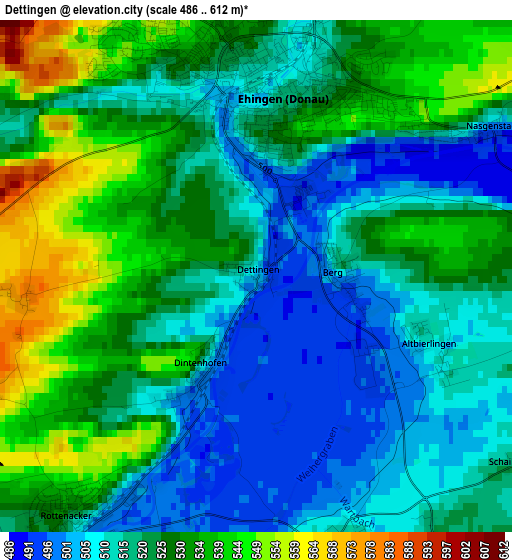
Below is the Elevation map of Dettingen, which displays elevation range with different colors. Scale of the first map is from 486 to 612 m (1594 to 2008 ft) with average elevation of 522 meters (=1713 ft) [note 1]
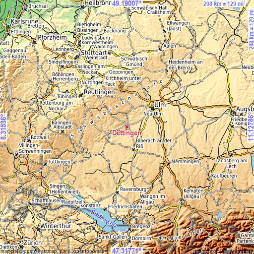
These maps also provides idea of topography and contour of this city, they are displayed at different zoom levels. More info about maps, scale and edge coordinates you can find below images.
| \ | Map #1 | Topo.Map |
| Scale [m] | 486..612 m | × |
| Scale [ft] | 1594..2008 ft | × |
| Average | 522 m = 1713 ft | × |
| Width | 6.51 km = 4 mi | 208.2 km = 129.4 mi |
| Height | 6.51 km = 4 mi | 208.2 km = 129.4 mi |
| ↑Max Latitude | 48.291707° | 49.19007° |
| Latitude at center | 48.26246° | 48.26246° |
| ↓Min Latitude | 48.233196° | 47.31771° |
| ← Min Longitude | 9.677665° | 8.31536° |
| Longitude center | 9.72161° | 9.72161° |
| →Max Longitude | 9.765555° | 11.12786° |
Nearby cities:
Cities around Dettingen sort by population:
• Ehingen elevation 518 m
2.3 km,  11°
11°
• Laupheim 504 m
12.3 km,  108°
108°
• Schelklingen 538 m
12.6 km,  3°
3°
• Munderkingen 518 m
6.5 km,  242°
242°
• Allmendingen 518 m
7.6 km, 1°
• Achstetten 503 m
13 km,  91°
91°
• Öpfingen 504 m
6.6 km,  66°
66°
• Rottenacker 523 m
3.9 km,  217°
217°
• Oberdischingen 491 m
9.3 km,  63°
63°
• Oberstadion 525 m
8.8 km,  194°
194°
• Obermarchtal 535 m
11.5 km,  253°
253°
• Ersingen 484 m
10.4 km, 71°
Multilingual:
 En español:
Dettingen elevación 503 m.
 En France:
Dettingen élévation 503 m.
 Auf Deutsch:
Dettingen höhe über dem Meeresspiegel ist 503 m.

Sources and notes:
- [note 1] Map square and city borders are not equal. Map elevation data is calculated only from area inside that square.
- [src 1] Elevation data from geonames database provided with same terms of usage.
- [src 2] The elevation map of Dettingen is generated using elevation data from NASA's 3 arcsec (90m) resolution SRTM data.
- [src 3] Base (background) map © OpenStreetMap contributors tiles are generated by Geofabrik and OpenTopoMap.
Copyright & License:
This Dettingen Elevation Map is licensed under CC BY-SA. You may reuse any part from this page, if you give a proper credit by linking to this URL:
 More info on terms of use page.