Dinkelsbühl elevation
Dinkelsbühl (Bavaria, Regierungsbezirk Mittelfranken), Germany elevation is 447 meters and Dinkelsbühl elevation in feet is 1467 ft above sea level [src 1]. Dinkelsbühl is a populated place (feature code) with elevation that is 189 meters (620 ft) bigger than average city elevation in Germany.
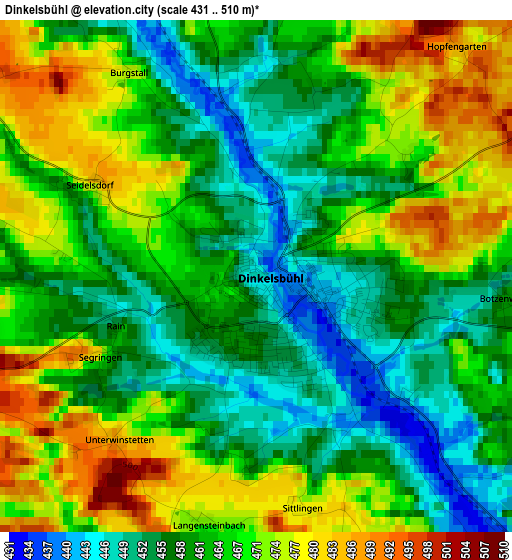
Below is the Elevation map of Dinkelsbühl, which displays elevation range with different colors. Scale of the first map is from 431 to 510 m (1414 to 1673 ft) with average elevation of 464.5 meters (=1524 ft) [note 1]
These maps also provides idea of topography and contour of this city, they are displayed at different zoom levels. More info about maps, scale and edge coordinates you can find below images.
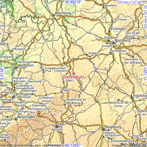
| \ | Map #1 | Map #2 | Topo.Map |
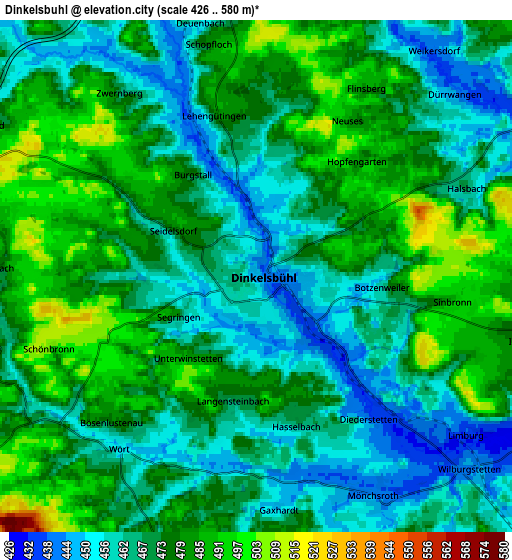
| Scale [m] | 431..510 m | 426..580 m | × |
| Scale [ft] | 1414..1673 ft | 1398..1903 ft | × |
| Average | 464.5 m = 1524 ft | 472.3 m = 1550 ft | × |
| Width | 6.4 km = 4 mi | 12.8 km = 8 mi | 204.9 km = 127.3 mi |
| Height | 6.4 km = 4 mi | 12.8 km = 8 mi | 204.9 km = 127.3 mi |
| ↑Max Latitude | 49.098202° | 49.126968° | 49.98219° |
| Latitude at center | 49.06942° | 49.06942° | 49.06942° |
| ↓Min Latitude | 49.040621° | 49.011806° | 48.13957° |
| ← Min Longitude | 10.275905° | 10.231959° | 8.9136° |
| Longitude center | 10.31985° | 10.31985° | 10.31985° |
| →Max Longitude | 10.363795° | 10.407741° | 11.7261° |
Nearby cities:
Cities around Dinkelsbühl sort by population:
• Feuchtwangen elevation 490 m
10.5 km,  7°
7°
• Lichtenau 489 m
10.9 km,  23°
23°
• Schopfloch 493 m
5.6 km,  350°
350°
• Dürrwangen 453 m
6.4 km,  48°
48°
• Langfurth 444 m
10.4 km,  70°
70°
• Wilburgstetten 444 m
7.4 km,  132°
132°
• Stödtlen 466 m
7.9 km,  190°
190°
• Tannhausen 517 m
10.5 km,  163°
163°
• Ellenberg 576 m
9.5 km,  232°
232°
• Mönchsroth 444 m
6.3 km,  153°
153°
• Wört 453 m
5.5 km,  218°
218°
• Weiltingen 442 m
10.1 km,  109°
109°
Multilingual:
 En español:
Dinkelsbühl elevación 447 m.
 En France:
Dinkelsbühl élévation 447 m.
 Auf Deutsch:
Dinkelsbühl höhe über dem Meeresspiegel ist 447 m.

Sources and notes:
- [note 1] Map square and city borders are not equal. Map elevation data is calculated only from area inside that square.
- [src 1] Elevation data from geonames database provided with same terms of usage.
- [src 2] The elevation map of Dinkelsbühl is generated using elevation data from NASA's 3 arcsec (90m) resolution SRTM data.
- [src 3] Base (background) map © OpenStreetMap contributors tiles are generated by Geofabrik and OpenTopoMap.
Copyright & License:
This Dinkelsbühl Elevation Map is licensed under CC BY-SA. You may reuse any part from this page, if you give a proper credit by linking to this URL:
 More info on terms of use page.