Ellzee elevation
Ellzee (Bavaria, Swabia), Germany elevation is 492 meters and Ellzee elevation in feet is 1614 ft above sea level [src 1]. Ellzee is a seat of a fourth-order administrative division (feature code) with elevation that is 234 meters (768 ft) bigger than average city elevation in Germany.
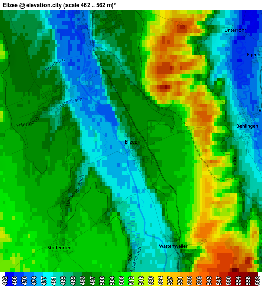
Below is the Elevation map of Ellzee, which displays elevation range with different colors. Scale of the first map is from 462 to 562 m (1516 to 1844 ft) with average elevation of 498.5 meters (=1635 ft) [note 1]
These maps also provides idea of topography and contour of this city, they are displayed at different zoom levels. More info about maps, scale and edge coordinates you can find below images.
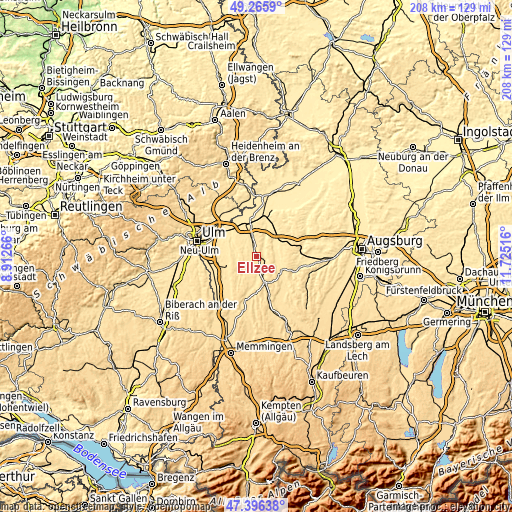
| \ | Map #1 | Topo.Map |
| Scale [m] | 462..562 m | × |
| Scale [ft] | 1516..1844 ft | × |
| Average | 498.5 m = 1635 ft | × |
| Width | 6.5 km = 4 mi | 207.9 km = 129.2 mi |
| Height | 6.5 km = 4 mi | 207.9 km = 129.2 mi |
| ↑Max Latitude | 48.368913° | 49.2659° |
| Latitude at center | 48.33971° | 48.33971° |
| ↓Min Latitude | 48.310491° | 47.39638° |
| ← Min Longitude | 10.274965° | 8.91266° |
| Longitude center | 10.31891° | 10.31891° |
| →Max Longitude | 10.362855° | 11.72516° |
Nearby cities:
Cities around Ellzee sort by population:
• Krumbach elevation 514 m
11.4 km,  163°
163°
• Ichenhausen 492 m
3.6 km,  345°
345°
• Pfaffenhofen an der Roth 488 m
11.7 km,  278°
278°
• Jettingen-Scheppach 472 m
10.4 km,  57°
57°
• Burtenbach 512 m
9.9 km,  89°
89°
• Rieden an der Kötz 485 m
6.8 km,  317°
317°
• Roggenburg 553 m
9.6 km,  222°
222°
• Münsterhausen 493 m
10.6 km,  108°
108°
• Deisenhausen 517 m
9.4 km,  176°
176°
• Bubesheim 467 m
11.6 km,  333°
333°
• Breitenthal 519 m
11.4 km,  187°
187°
• Waldstetten 489 m
2.1 km,  296°
296°
Multilingual:
 En español:
Ellzee elevación 492 m.
 En France:
Ellzee élévation 492 m.


Sources and notes:
- [note 1] Map square and city borders are not equal. Map elevation data is calculated only from area inside that square.
- [src 1] Elevation data from geonames database provided with same terms of usage.
- [src 2] The elevation map of Ellzee is generated using elevation data from NASA's 3 arcsec (90m) resolution SRTM data.
- [src 3] Base (background) map © OpenStreetMap contributors tiles are generated by Geofabrik and OpenTopoMap.
Copyright & License:
This Ellzee Elevation Map is licensed under CC BY-SA. You may reuse any part from this page, if you give a proper credit by linking to this URL:
 More info on terms of use page.