Ensdorf elevation
Ensdorf (Saarland), Germany elevation is 198 meters and Ensdorf elevation in feet is 650 ft above sea level [src 1]. Ensdorf is a seat of a fourth-order administrative division (feature code) with elevation that is 60 meters (197 ft) smaller than average city elevation in Germany.
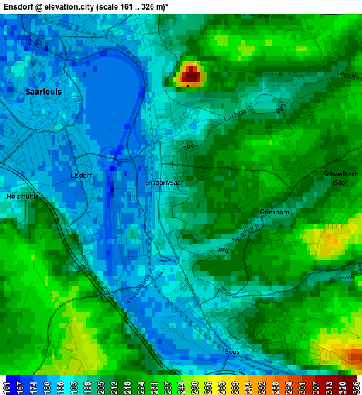
Below is the Elevation map of Ensdorf, which displays elevation range with different colors. Scale of the first map is from 161 to 326 m (528 to 1070 ft) with average elevation of 207.7 meters (=681 ft) [note 1]
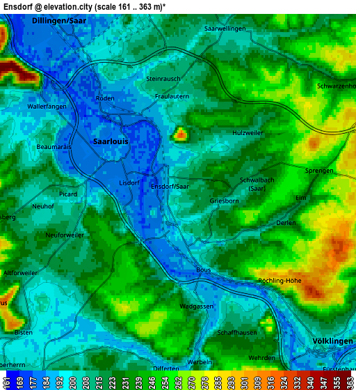
These maps also provides idea of topography and contour of this city, they are displayed at different zoom levels. More info about maps, scale and edge coordinates you can find below images.
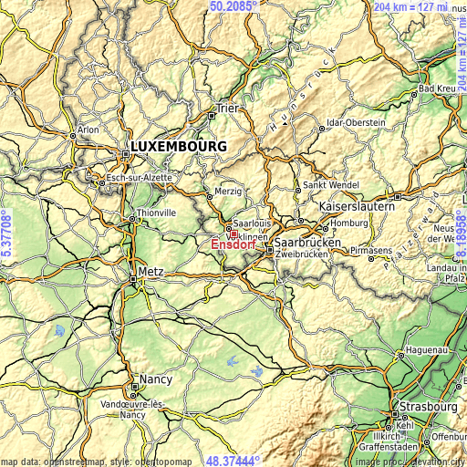
| \ | Map #1 | Map #2 | Topo.Map |
| Scale [m] | 161..326 m | 161..363 m | × |
| Scale [ft] | 528..1070 ft | 528..1191 ft | × |
| Average | 207.7 m = 681 ft | 220.5 m = 723 ft | × |
| Width | 6.37 km = 4 mi | 12.75 km = 7.9 mi | 203.9 km = 126.7 mi |
| Height | 6.37 km = 4 mi | 12.75 km = 7.9 mi | 203.9 km = 126.7 mi |
| ↑Max Latitude | 49.328648° | 49.35728° | 50.2085° |
| Latitude at center | 49.3° | 49.3° | 49.3° |
| ↓Min Latitude | 49.271335° | 49.242653° | 48.37444° |
| ← Min Longitude | 6.739385° | 6.695439° | 5.37708° |
| Longitude center | 6.78333° | 6.78333° | 6.78333° |
| →Max Longitude | 6.827275° | 6.871221° | 8.18958° |
Nearby cities:
Cities around Ensdorf sort by population:
• Völklingen elevation 197 m
7.7 km,  134°
134°
• Saarlouis 183 m
2.8 km,  303°
303°
• Dillingen 190 m
7.4 km,  326°
326°
• Püttlingen 227 m
7.7 km,  102°
102°
• Schwalbach 210 m
2.4 km,  90°
90°
• Wadgassen 230 m
3.7 km,  180°
180°
• Saarwellingen 205 m
6.2 km,  14°
14°
• Überherrn 211 m
8.9 km,  223°
223°
• Wallerfangen 188 m
6.1 km, 300°
• Bous 223 m
2.8 km,  152°
152°
• Heidstock 235 m
8.7 km,  124°
124°
• Röchling-Höhe 287 m
4.9 km, 130°
Multilingual:
 En español:
Ensdorf elevación 198 m.
 En France:
Ensdorf élévation 198 m.


Sources and notes:
- [note 1] Map square and city borders are not equal. Map elevation data is calculated only from area inside that square.
- [src 1] Elevation data from geonames database provided with same terms of usage.
- [src 2] The elevation map of Ensdorf is generated using elevation data from NASA's 3 arcsec (90m) resolution SRTM data.
- [src 3] Base (background) map © OpenStreetMap contributors tiles are generated by Geofabrik and OpenTopoMap.
Copyright & License:
This Ensdorf Elevation Map is licensed under CC BY-SA. You may reuse any part from this page, if you give a proper credit by linking to this URL:
 More info on terms of use page.