Flöha elevation
Flöha (Saxony), Germany elevation is 273 meters and Flöha elevation in feet is 896 ft above sea level [src 1]. Flöha is a populated place (feature code) with elevation that is 15 meters (49 ft) bigger than average city elevation in Germany.
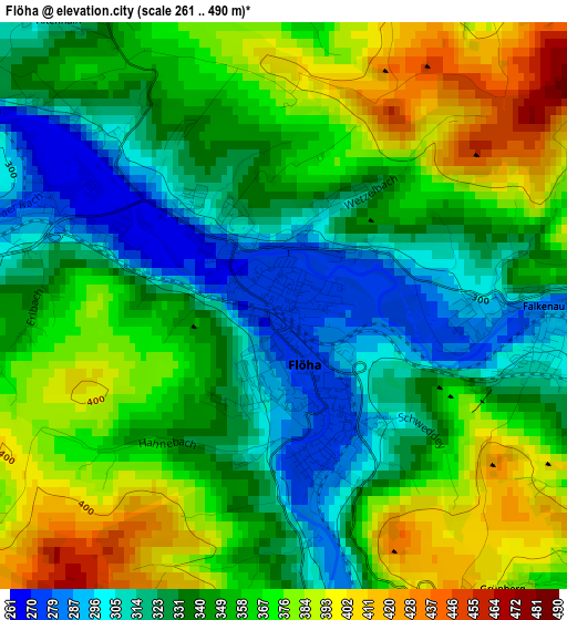
Below is the Elevation map of Flöha, which displays elevation range with different colors. Scale of the first map is from 261 to 490 m (856 to 1608 ft) with average elevation of 350.2 meters (=1149 ft) [note 1]
These maps also provides idea of topography and contour of this city, they are displayed at different zoom levels. More info about maps, scale and edge coordinates you can find below images.
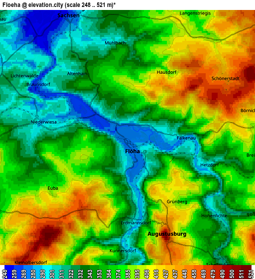
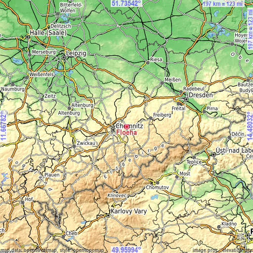
| \ | Map #1 | Map #2 | Topo.Map |
| Scale [m] | 261..490 m | 248..521 m | × |
| Scale [ft] | 856..1608 ft | 814..1709 ft | × |
| Average | 350.2 m = 1149 ft | 366.9 m = 1204 ft | × |
| Width | 6.17 km = 3.8 mi | 12.34 km = 7.7 mi | 197.4 km = 122.7 mi |
| Height | 6.17 km = 3.8 mi | 12.34 km = 7.7 mi | 197.4 km = 122.7 mi |
| ↑Max Latitude | 50.883863° | 50.91158° | 51.73542° |
| Latitude at center | 50.85613° | 50.85613° | 50.85613° |
| ↓Min Latitude | 50.82838° | 50.800614° | 49.95994° |
| ← Min Longitude | 13.030125° | 12.986179° | 11.66782° |
| Longitude center | 13.07407° | 13.07407° | 13.07407° |
| →Max Longitude | 13.118015° | 13.161961° | 14.48032° |
Nearby cities:
Cities around Flöha sort by population:
• Chemnitz elevation 306 m
10.4 km,  257°
257°
• Frankenberg 279 m
6.8 km,  339°
339°
• Oederan 374 m
6.9 km,  85°
85°
• Niederwiesa 303 m
4.2 km,  286°
286°
• Augustusburg 479 m
5.3 km,  158°
158°
• Gornau 445 m
11.1 km,  193°
193°
• Leubsdorf 407 m
9 km,  133°
133°
• Falkenau 283 m
3 km, 91°
• Hilbersdorf 346 m
8.9 km,  268°
268°
• Grünhainichen 427 m
11.4 km,  150°
150°
• Borstendorf 399 m
11.8 km,  141°
141°
• Frankenstein 375 m
10.7 km,  62°
62°
Multilingual:
 En español:
Flöha elevación 273 m.
 En France:
Flöha élévation 273 m.


Sources and notes:
- [note 1] Map square and city borders are not equal. Map elevation data is calculated only from area inside that square.
- [src 1] Elevation data from geonames database provided with same terms of usage.
- [src 2] The elevation map of Flöha is generated using elevation data from NASA's 3 arcsec (90m) resolution SRTM data.
- [src 3] Base (background) map © OpenStreetMap contributors tiles are generated by Geofabrik and OpenTopoMap.
Copyright & License:
This Flöha Elevation Map is licensed under CC BY-SA. You may reuse any part from this page, if you give a proper credit by linking to this URL:
 More info on terms of use page.