Föritz elevation
Föritz (Thuringia), Germany elevation is 411 meters and Föritz elevation in feet is 1348 ft above sea level [src 1]. Föritz is a populated place (feature code) with elevation that is 153 meters (502 ft) bigger than average city elevation in Germany.
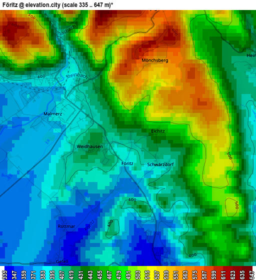
Below is the Elevation map of Föritz, which displays elevation range with different colors. Scale of the first map is from 335 to 647 m (1099 to 2123 ft) with average elevation of 441.5 meters (=1448 ft) [note 1]
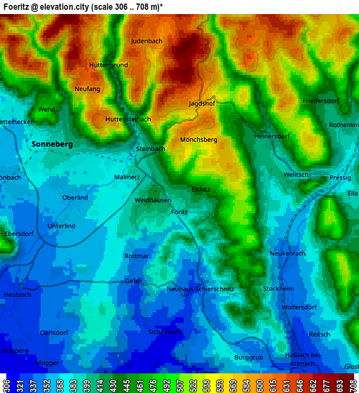
These maps also provides idea of topography and contour of this city, they are displayed at different zoom levels. More info about maps, scale and edge coordinates you can find below images.
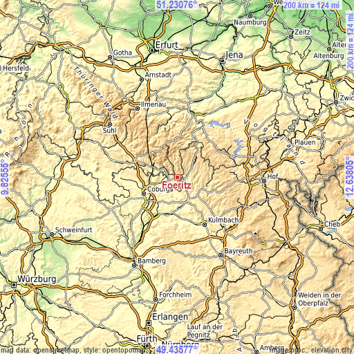
| \ | Map #1 | Map #2 | Topo.Map |
| Scale [m] | 335..647 m | 306..708 m | × |
| Scale [ft] | 1099..2123 ft | 1004..2323 ft | × |
| Average | 441.5 m = 1448 ft | 438.5 m = 1439 ft | × |
| Width | 6.24 km = 3.9 mi | 12.47 km = 7.7 mi | 199.6 km = 124 mi |
| Height | 6.24 km = 3.9 mi | 12.47 km = 7.7 mi | 199.6 km = 124 mi |
| ↑Max Latitude | 50.369778° | 50.397799° | 51.23076° |
| Latitude at center | 50.34174° | 50.34174° | 50.34174° |
| ↓Min Latitude | 50.313686° | 50.285614° | 49.43577° |
| ← Min Longitude | 11.187855° | 11.143909° | 9.82555° |
| Longitude center | 11.2318° | 11.2318° | 11.2318° |
| →Max Longitude | 11.275745° | 11.319691° | 12.63805° |
Nearby cities:
Cities around Föritz sort by population:
• Sonneberg elevation 398 m
4.5 km,  295°
295°
• Neustadt bei Coburg 340 m
8 km,  260°
260°
• Ebersdorf 350 m
5.8 km, 255°
• Stockheim 343 m
5.3 km,  137°
137°
• Steinach 492 m
11.2 km,  332°
332°
• Pressig 392 m
5.7 km,  77°
77°
• Wilhelmsthal 463 m
10.6 km,  108°
108°
• Neuhaus-Schierschnitz 336 m
3.3 km,  169°
169°
• Mitwitz 299 m
10.2 km,  189°
189°
• Mengersgereuth-Hämmern 500 m
10.2 km,  307°
307°
• Judenbach 630 m
6.1 km,  352°
352°
• Teuschnitz 617 m
12.4 km,  59°
59°
Multilingual:
 En español:
Föritz elevación 411 m.
 En France:
Föritz élévation 411 m.


Sources and notes:
- [note 1] Map square and city borders are not equal. Map elevation data is calculated only from area inside that square.
- [src 1] Elevation data from geonames database provided with same terms of usage.
- [src 2] The elevation map of Föritz is generated using elevation data from NASA's 3 arcsec (90m) resolution SRTM data.
- [src 3] Base (background) map © OpenStreetMap contributors tiles are generated by Geofabrik and OpenTopoMap.
Copyright & License:
This Föritz Elevation Map is licensed under CC BY-SA. You may reuse any part from this page, if you give a proper credit by linking to this URL:
 More info on terms of use page.