Fraureuth elevation
Fraureuth (Saxony), Germany elevation is 309 meters and Fraureuth elevation in feet is 1014 ft above sea level [src 1]. Fraureuth is a seat of a fourth-order administrative division (feature code) with elevation that is 51 meters (167 ft) bigger than average city elevation in Germany.
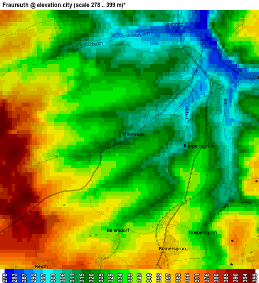
Below is the Elevation map of Fraureuth, which displays elevation range with different colors. Scale of the first map is from 278 to 399 m (912 to 1309 ft) with average elevation of 335.4 meters (=1100 ft) [note 1]
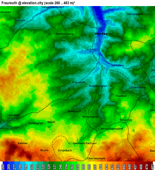
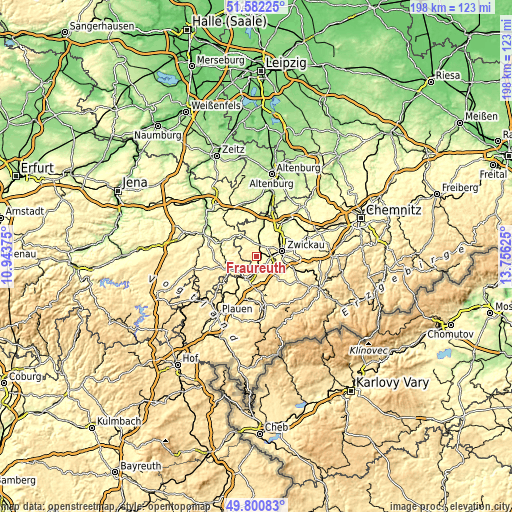
These maps also provides idea of topography and contour of this city, they are displayed at different zoom levels. More info about maps, scale and edge coordinates you can find below images.
| \ | Map #1 | Map #2 | Topo.Map |
| Scale [m] | 278..399 m | 260..483 m | × |
| Scale [ft] | 912..1309 ft | 853..1585 ft | × |
| Average | 335.4 m = 1100 ft | 356.3 m = 1169 ft | × |
| Width | 6.19 km = 3.8 mi | 12.38 km = 7.7 mi | 198.1 km = 123.1 mi |
| Height | 6.19 km = 3.8 mi | 12.38 km = 7.7 mi | 198.1 km = 123.1 mi |
| ↑Max Latitude | 50.727826° | 50.755635° | 51.58225° |
| Latitude at center | 50.7° | 50.7° | 50.7° |
| ↓Min Latitude | 50.672158° | 50.644299° | 49.80083° |
| ← Min Longitude | 12.306055° | 12.262109° | 10.94375° |
| Longitude center | 12.35° | 12.35° | 12.35° |
| →Max Longitude | 12.393945° | 12.437891° | 13.75625° |
Nearby cities:
Cities around Fraureuth sort by population:
• Zwickau elevation 267 m
10.2 km,  72°
72°
• Werdau 274 m
4.4 km,  23°
23°
• Reichenbach/Vogtland 381 m
9.2 km,  200°
200°
• Lichtentanne 325 m
5.4 km,  98°
98°
• Langenbernsdorf 279 m
6.4 km,  345°
345°
• Neumark 354 m
4.5 km,  174°
174°
• Mohlsdorf 313 m
6.9 km,  240°
240°
• Mylau 319 m
10.8 km,  213°
213°
• Weißenborn 289 m
9.6 km,  62°
62°
• Teichwolframsdorf 314 m
7.6 km,  287°
287°
• Leubnitz 291 m
2.6 km,  10°
10°
• Hartmannsdorf 308 m
8.4 km,  39°
39°
Multilingual:
 En español:
Fraureuth elevación 309 m.
 En France:
Fraureuth élévation 309 m.
 Auf Deutsch:
Fraureuth höhe über dem Meeresspiegel ist 309 m.

Sources and notes:
- [note 1] Map square and city borders are not equal. Map elevation data is calculated only from area inside that square.
- [src 1] Elevation data from geonames database provided with same terms of usage.
- [src 2] The elevation map of Fraureuth is generated using elevation data from NASA's 3 arcsec (90m) resolution SRTM data.
- [src 3] Base (background) map © OpenStreetMap contributors tiles are generated by Geofabrik and OpenTopoMap.
Copyright & License:
This Fraureuth Elevation Map is licensed under CC BY-SA. You may reuse any part from this page, if you give a proper credit by linking to this URL:
 More info on terms of use page.