Freising elevation
Freising (Bavaria, Upper Bavaria), Germany elevation is 448 meters and Freising elevation in feet is 1470 ft above sea level [src 1]. Freising is a seat of a third-order administrative division (feature code) with elevation that is 190 meters (623 ft) bigger than average city elevation in Germany.
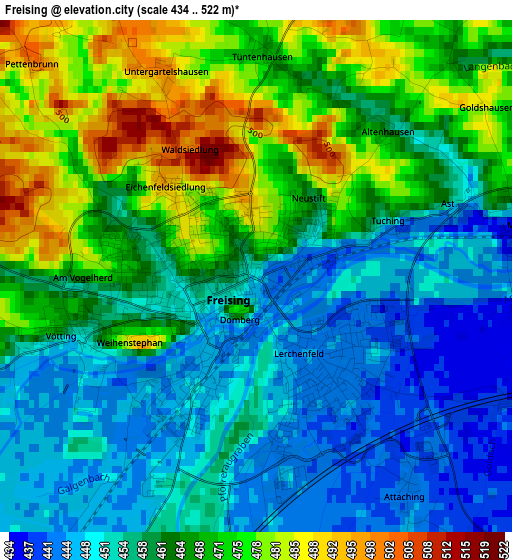
Below is the Elevation map of Freising, which displays elevation range with different colors. Scale of the first map is from 434 to 522 m (1424 to 1713 ft) with average elevation of 461.9 meters (=1515 ft) [note 1]
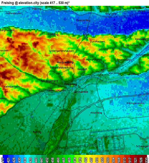
These maps also provides idea of topography and contour of this city, they are displayed at different zoom levels. More info about maps, scale and edge coordinates you can find below images.

| \ | Map #1 | Map #2 | Topo.Map |
| Scale [m] | 434..522 m | 417..530 m | × |
| Scale [ft] | 1424..1713 ft | 1368..1739 ft | × |
| Average | 461.9 m = 1515 ft | 454.8 m = 1492 ft | × |
| Width | 6.49 km = 4 mi | 12.98 km = 8.1 mi | 207.6 km = 129 mi |
| Height | 6.49 km = 4 mi | 12.98 km = 8.1 mi | 207.6 km = 129 mi |
| ↑Max Latitude | 48.432676° | 48.461825° | 49.32854° |
| Latitude at center | 48.40351° | 48.40351° | 48.40351° |
| ↓Min Latitude | 48.374327° | 48.345128° | 47.46135° |
| ← Min Longitude | 11.704815° | 11.660869° | 10.34251° |
| Longitude center | 11.74876° | 11.74876° | 11.74876° |
| →Max Longitude | 11.792705° | 11.836651° | 13.15501° |
Nearby cities:
Cities around Freising sort by population:
• Neufahrn bei Freising elevation 462 m
11.6 km,  212°
212°
• Hallbergmoos 456 m
8.5 km,  178°
178°
• Oberding 463 m
12.2 km,  142°
142°
• Allershausen 444 m
11.5 km,  286°
286°
• Zolling 429 m
5.3 km,  14°
14°
• Langenbach 434 m
8.2 km,  66°
66°
• Haag an der Amper 437 m
8.4 km,  43°
43°
• Marzling 442 m
3.4 km,  79°
79°
• Kirchdorf 441 m
9.3 km,  311°
311°
• Attenkirchen 519 m
11.3 km,  4°
4°
• Wolfersdorf 501 m
8.9 km,  341°
341°
• Eitting 446 m
11.6 km,  114°
114°
Multilingual:
 En español:
Frisinga elevación 448 m.
 En France:
Freising élévation 448 m.
 Auf Deutsch:
Freising höhe über dem Meeresspiegel ist 448 m.

Sources and notes:
- [note 1] Map square and city borders are not equal. Map elevation data is calculated only from area inside that square.
- [src 1] Elevation data from geonames database provided with same terms of usage.
- [src 2] The elevation map of Freising is generated using elevation data from NASA's 3 arcsec (90m) resolution SRTM data.
- [src 3] Base (background) map © OpenStreetMap contributors tiles are generated by Geofabrik and OpenTopoMap.
Copyright & License:
This Freising Elevation Map is licensed under CC BY-SA. You may reuse any part from this page, if you give a proper credit by linking to this URL:
 More info on terms of use page.