Friedland elevation
Friedland (Mecklenburg-Vorpommern), Germany elevation is 16 meters and Friedland elevation in feet is 52 ft above sea level [src 1]. Friedland is a populated place (feature code) with elevation that is 242 meters (794 ft) smaller than average city elevation in Germany.
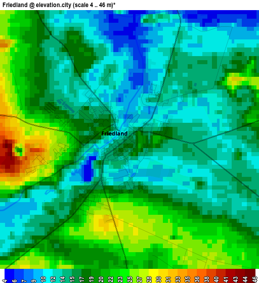
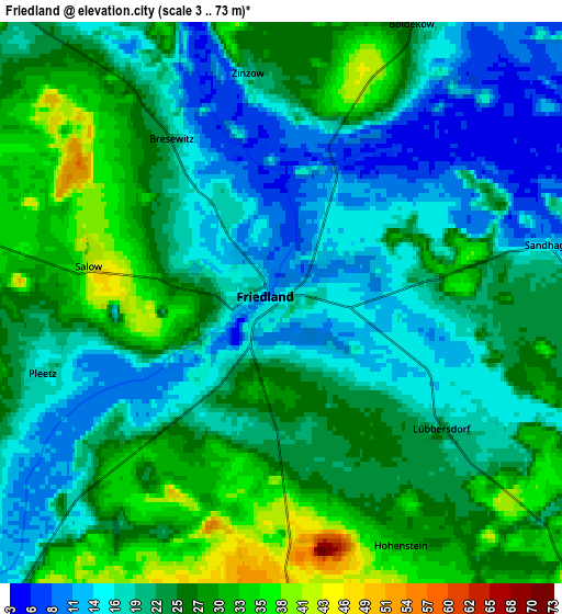
Below is the Elevation map of Friedland, which displays elevation range with different colors. Scale of the first map is from 4 to 46 m (13 to 151 ft) with average elevation of 17.1 meters (=56 ft) [note 1]
These maps also provides idea of topography and contour of this city, they are displayed at different zoom levels. More info about maps, scale and edge coordinates you can find below images.
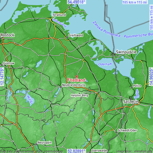
| \ | Map #1 | Map #2 | Topo.Map |
| Scale [m] | 4..46 m | 3..73 m | × |
| Scale [ft] | 13..151 ft | 10..240 ft | × |
| Average | 17.1 m = 56 ft | 22.5 m = 74 ft | × |
| Width | 5.79 km = 3.6 mi | 11.58 km = 7.2 mi | 185.3 km = 115.1 mi |
| Height | 5.79 km = 3.6 mi | 11.58 km = 7.2 mi | 185.3 km = 115.1 mi |
| ↑Max Latitude | 53.696307° | 53.722317° | 54.49518° |
| Latitude at center | 53.67028° | 53.67028° | 53.67028° |
| ↓Min Latitude | 53.644237° | 53.618179° | 52.82891° |
| ← Min Longitude | 13.510055° | 13.466109° | 12.14775° |
| Longitude center | 13.554° | 13.554° | 13.554° |
| →Max Longitude | 13.597945° | 13.641891° | 14.96025° |
Nearby cities:
Cities around Friedland sort by population:
• Neubrandenburg elevation 18 m
21.8 km,  237°
237°
• Altentreptow 21 m
19.2 km,  277°
277°
• Strasburg 63 m
21.8 km,  144°
144°
• Alt-Sanitz 8 m
16.1 km,  7°
7°
• Ducherow 7 m
18.3 km,  55°
55°
• Kessin 31 m
17.5 km,  292°
292°
• Groß Miltzow 91 m
15.2 km,  170°
170°
• Brunn 30 m
12.1 km,  270°
270°
• Burow 40 m
21.8 km,  301°
301°
• Neuenkirchen 73 m
14.6 km, 236°
• Neverin 65 m
15.4 km,  248°
248°
• Trollenhagen 66 m
18.7 km, 247°
Multilingual:
 En español:
Friedland elevación 16 m.
 En France:
Friedland élévation 16 m.
 Auf Deutsch:
Friedland höhe über dem Meeresspiegel ist 16 m.

Sources and notes:
- [note 1] Map square and city borders are not equal. Map elevation data is calculated only from area inside that square.
- [src 1] Elevation data from geonames database provided with same terms of usage.
- [src 2] The elevation map of Friedland is generated using elevation data from NASA's 3 arcsec (90m) resolution SRTM data.
- [src 3] Base (background) map © OpenStreetMap contributors tiles are generated by Geofabrik and OpenTopoMap.
Copyright & License:
This Friedland Elevation Map is licensed under CC BY-SA. You may reuse any part from this page, if you give a proper credit by linking to this URL:
 More info on terms of use page.