Gillenfeld elevation
Gillenfeld (Rheinland-Pfalz), Germany elevation is 397 meters and Gillenfeld elevation in feet is 1302 ft above sea level [src 1]. Gillenfeld is a seat of a fourth-order administrative division (feature code) with elevation that is 139 meters (456 ft) bigger than average city elevation in Germany.
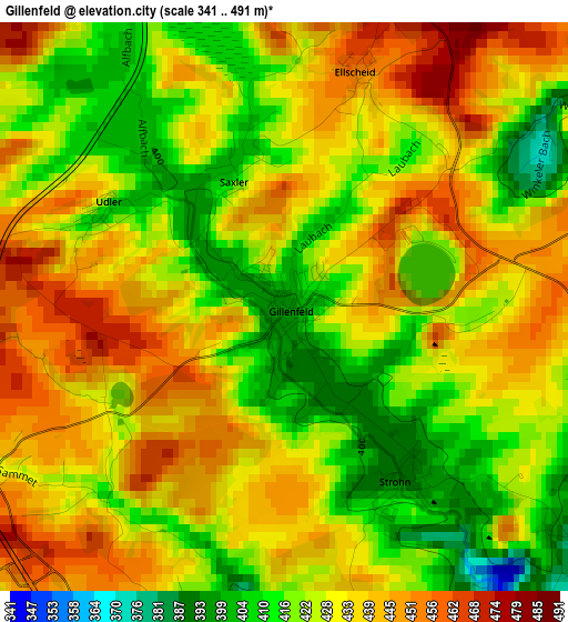
Below is the Elevation map of Gillenfeld, which displays elevation range with different colors. Scale of the first map is from 341 to 491 m (1119 to 1611 ft) with average elevation of 429.5 meters (=1409 ft) [note 1]
These maps also provides idea of topography and contour of this city, they are displayed at different zoom levels. More info about maps, scale and edge coordinates you can find below images.
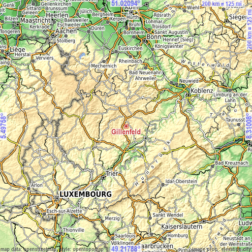
| \ | Map #1 | Topo.Map |
| Scale [m] | 341..491 m | × |
| Scale [ft] | 1119..1611 ft | × |
| Average | 429.5 m = 1409 ft | × |
| Width | 6.26 km = 3.9 mi | 200.5 km = 124.6 mi |
| Height | 6.26 km = 3.9 mi | 200.5 km = 124.6 mi |
| ↑Max Latitude | 50.156064° | 51.02094° |
| Latitude at center | 50.1279° | 50.1279° |
| ↓Min Latitude | 50.099719° | 49.21788° |
| ← Min Longitude | 6.859885° | 5.49758° |
| Longitude center | 6.90383° | 6.90383° |
| →Max Longitude | 6.947775° | 8.31008° |
Nearby cities:
Cities around Gillenfeld sort by population:
• Daun elevation 432 m
9.3 km,  325°
325°
• Ulmen 429 m
10.5 km,  30°
30°
• Neuerburg 202 m
14.5 km,  167°
167°
• Lutzerath 419 m
7.4 km,  90°
90°
• Mehren 498 m
6.3 km,  346°
346°
• Bausendorf 224 m
14.1 km,  150°
150°
• Manderscheid 388 m
7.5 km,  242°
242°
• Üdersdorf 440 m
7.8 km,  288°
288°
• Faid 391 m
15.5 km,  83°
83°
• Büchel 451 m
13.7 km,  68°
68°
• Kinderbeuern 164 m
15.7 km, 147°
• Großlittgen 310 m
13.4 km,  214°
214°
Multilingual:
 En español:
Gillenfeld elevación 397 m.
 En France:
Gillenfeld élévation 397 m.
 Auf Deutsch:
Gillenfeld höhe über dem Meeresspiegel ist 397 m.

Sources and notes:
- [note 1] Map square and city borders are not equal. Map elevation data is calculated only from area inside that square.
- [src 1] Elevation data from geonames database provided with same terms of usage.
- [src 2] The elevation map of Gillenfeld is generated using elevation data from NASA's 3 arcsec (90m) resolution SRTM data.
- [src 3] Base (background) map © OpenStreetMap contributors tiles are generated by Geofabrik and OpenTopoMap.
Copyright & License:
This Gillenfeld Elevation Map is licensed under CC BY-SA. You may reuse any part from this page, if you give a proper credit by linking to this URL:
 More info on terms of use page.