Glauchau elevation
Glauchau (Saxony), Germany elevation is 266 meters and Glauchau elevation in feet is 873 ft above sea level [src 1]. Glauchau is a populated place (feature code) with elevation that is 8 meters (26 ft) bigger than average city elevation in Germany.
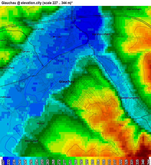
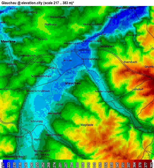
Below is the Elevation map of Glauchau, which displays elevation range with different colors. Scale of the first map is from 227 to 344 m (745 to 1129 ft) with average elevation of 266.1 meters (=873 ft) [note 1]
These maps also provides idea of topography and contour of this city, they are displayed at different zoom levels. More info about maps, scale and edge coordinates you can find below images.
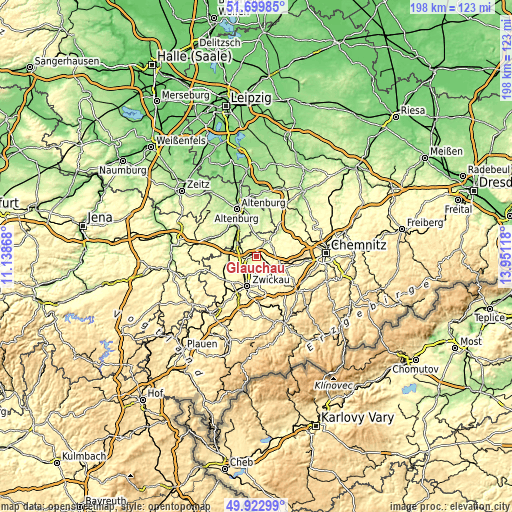
| \ | Map #1 | Map #2 | Topo.Map |
| Scale [m] | 227..344 m | 217..383 m | × |
| Scale [ft] | 745..1129 ft | 712..1257 ft | × |
| Average | 266.1 m = 873 ft | 283.3 m = 929 ft | × |
| Width | 6.17 km = 3.8 mi | 12.35 km = 7.7 mi | 197.6 km = 122.8 mi |
| Height | 6.17 km = 3.8 mi | 12.35 km = 7.7 mi | 197.6 km = 122.8 mi |
| ↑Max Latitude | 50.847625° | 50.875363° | 51.69985° |
| Latitude at center | 50.81987° | 50.81987° | 50.81987° |
| ↓Min Latitude | 50.792099° | 50.764311° | 49.92299° |
| ← Min Longitude | 12.500985° | 12.457039° | 11.13868° |
| Longitude center | 12.54493° | 12.54493° | 12.54493° |
| →Max Longitude | 12.588875° | 12.632821° | 13.95118° |
Nearby cities:
Cities around Glauchau sort by population:
• Meerane elevation 248 m
6.4 km,  298°
298°
• Lichtenstein 308 m
9.2 km,  139°
139°
• Mülsen 318 m
7.9 km,  168°
168°
• Callenberg 328 m
7.1 km,  61°
61°
• Waldenburg 267 m
7.4 km,  31°
31°
• Sankt Egidien 269 m
6.7 km,  124°
124°
• Pfaffroda 297 m
5.1 km,  335°
335°
• Remse 254 m
3.7 km,  24°
24°
• Ponitz 220 m
9.5 km, 296°
• Dennheritz 296 m
5.6 km,  263°
263°
• Oberwiera 249 m
7.7 km,  359°
359°
• Schönberg 267 m
6.5 km,  324°
324°
Multilingual:
 En español:
Glauchau elevación 266 m.
 En France:
Glauchau élévation 266 m.
 Auf Deutsch:
Glauchau höhe über dem Meeresspiegel ist 266 m.

Sources and notes:
- [note 1] Map square and city borders are not equal. Map elevation data is calculated only from area inside that square.
- [src 1] Elevation data from geonames database provided with same terms of usage.
- [src 2] The elevation map of Glauchau is generated using elevation data from NASA's 3 arcsec (90m) resolution SRTM data.
- [src 3] Base (background) map © OpenStreetMap contributors tiles are generated by Geofabrik and OpenTopoMap.
Copyright & License:
This Glauchau Elevation Map is licensed under CC BY-SA. You may reuse any part from this page, if you give a proper credit by linking to this URL:
 More info on terms of use page.