Gries elevation
Gries (Rheinland-Pfalz), Germany elevation is 259 meters and Gries elevation in feet is 850 ft above sea level [src 1]. Gries is a seat of a fourth-order administrative division (feature code) with elevation that is 1 meters (3 ft) bigger than average city elevation in Germany.
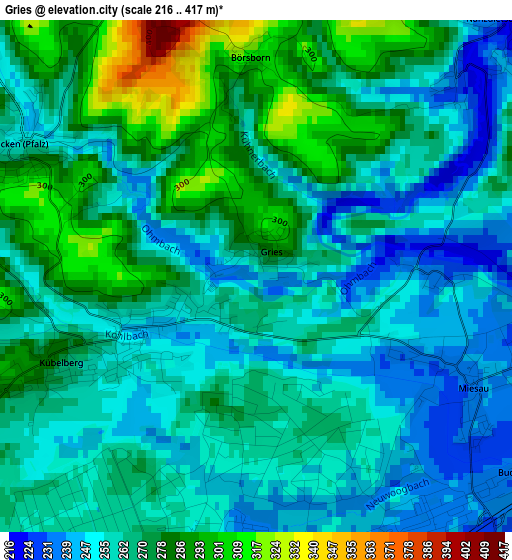
Below is the Elevation map of Gries, which displays elevation range with different colors. Scale of the first map is from 216 to 417 m (709 to 1368 ft) with average elevation of 265.2 meters (=870 ft) [note 1]
These maps also provides idea of topography and contour of this city, they are displayed at different zoom levels. More info about maps, scale and edge coordinates you can find below images.
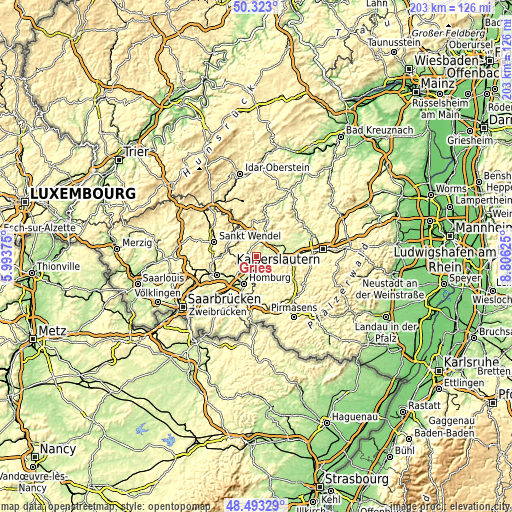
| \ | Map #1 | Topo.Map |
| Scale [m] | 216..417 m | × |
| Scale [ft] | 709..1368 ft | × |
| Average | 265.2 m = 870 ft | × |
| Width | 6.36 km = 4 mi | 203.4 km = 126.4 mi |
| Height | 6.36 km = 4 mi | 203.4 km = 126.4 mi |
| ↑Max Latitude | 49.44525° | 50.323° |
| Latitude at center | 49.41667° | 49.41667° |
| ↓Min Latitude | 49.388073° | 48.49329° |
| ← Min Longitude | 7.356055° | 5.99375° |
| Longitude center | 7.4° | 7.4° |
| →Max Longitude | 7.443945° | 8.80625° |
Nearby cities:
Cities around Gries sort by population:
• Bruchmühlbach-Miesau elevation 232 m
4.4 km,  146°
146°
• Schönenberg-Kübelberg 264 m
2.3 km,  242°
242°
• Waldmohr 270 m
6.1 km,  232°
232°
• Hütschenhausen 227 m
6 km,  90°
90°
• Brücken 251 m
3.3 km,  300°
300°
• Bechhofen 315 m
7.4 km,  180°
180°
• Martinshöhe 385 m
8.2 km,  132°
132°
• Niedermohr 223 m
6.9 km,  46°
46°
• Altenkirchen 294 m
6.4 km, 297°
• Hauptstuhl 235 m
6.3 km,  107°
107°
• Nanzdietschweiler 280 m
5.2 km,  44°
44°
• Glan-Münchweiler 226 m
6.9 km,  26°
26°
Multilingual:
 En español:
Gries elevación 259 m.
 En France:
Gries élévation 259 m.


Sources and notes:
- [note 1] Map square and city borders are not equal. Map elevation data is calculated only from area inside that square.
- [src 1] Elevation data from geonames database provided with same terms of usage.
- [src 2] The elevation map of Gries is generated using elevation data from NASA's 3 arcsec (90m) resolution SRTM data.
- [src 3] Base (background) map © OpenStreetMap contributors tiles are generated by Geofabrik and OpenTopoMap.
Copyright & License:
This Gries Elevation Map is licensed under CC BY-SA. You may reuse any part from this page, if you give a proper credit by linking to this URL:
 More info on terms of use page.