Großhansdorf elevation
Großhansdorf (Schleswig-Holstein), Germany elevation is 47 meters and Großhansdorf elevation in feet is 154 ft above sea level [src 1]. Großhansdorf is a seat of a fourth-order administrative division (feature code) with elevation that is 211 meters (692 ft) smaller than average city elevation in Germany.
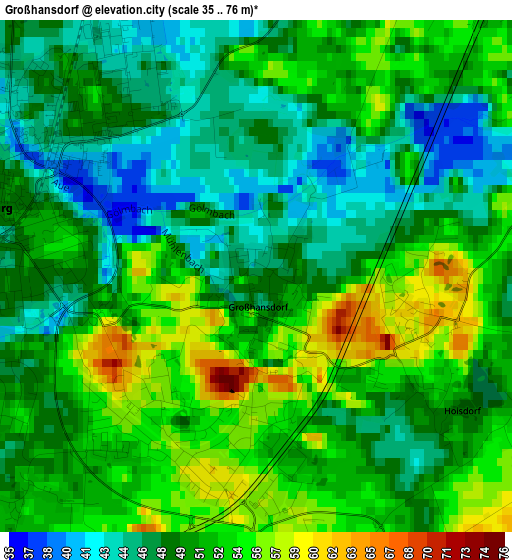
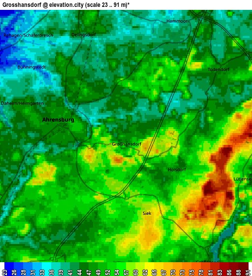
Below is the Elevation map of Großhansdorf, which displays elevation range with different colors. Scale of the first map is from 35 to 76 m (115 to 249 ft) with average elevation of 50.2 meters (=165 ft) [note 1]
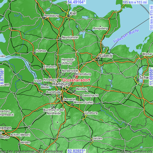
These maps also provides idea of topography and contour of this city, they are displayed at different zoom levels. More info about maps, scale and edge coordinates you can find below images.
| \ | Map #1 | Map #2 | Topo.Map |
| Scale [m] | 35..76 m | 23..91 m | × |
| Scale [ft] | 115..249 ft | 75..299 ft | × |
| Average | 50.2 m = 165 ft | 49.3 m = 162 ft | × |
| Width | 5.79 km = 3.6 mi | 11.58 km = 7.2 mi | 185.3 km = 115.1 mi |
| Height | 5.79 km = 3.6 mi | 11.58 km = 7.2 mi | 185.3 km = 115.1 mi |
| ↑Max Latitude | 53.692699° | 53.718711° | 54.49164° |
| Latitude at center | 53.66667° | 53.66667° | 53.66667° |
| ↓Min Latitude | 53.640625° | 53.614564° | 52.82523° |
| ← Min Longitude | 10.239385° | 10.195439° | 8.87708° |
| Longitude center | 10.28333° | 10.28333° | 10.28333° |
| →Max Longitude | 10.327275° | 10.371221° | 11.68958° |
Nearby cities:
Cities around Großhansdorf sort by population:
• Ahrensburg elevation 44 m
3.9 km,  284°
284°
• Bargteheide 51 m
7 km,  351°
351°
• Hoisdorf 51 m
2.9 km,  130°
130°
• Lütjensee 53 m
5.8 km,  108°
108°
• Delingsdorf 39 m
4.3 km,  329°
329°
• Siek 64 m
3.9 km,  163°
163°
• Jersbek 28 m
8.6 km, 329°
• Großensee 44 m
7.1 km,  148°
148°
• Stapelfeld 42 m
8.6 km,  210°
210°
• Grönwohld 40 m
8.7 km, 108°
• Hammoor 40 m
5.8 km,  25°
25°
• Todendorf 48 m
5.3 km,  53°
53°
Multilingual:
 En español:
Großhansdorf elevación 47 m.
 En France:
Großhansdorf élévation 47 m.
 Auf Deutsch:
Großhansdorf höhe über dem Meeresspiegel ist 47 m.

Sources and notes:
- [note 1] Map square and city borders are not equal. Map elevation data is calculated only from area inside that square.
- [src 1] Elevation data from geonames database provided with same terms of usage.
- [src 2] The elevation map of Großhansdorf is generated using elevation data from NASA's 3 arcsec (90m) resolution SRTM data.
- [src 3] Base (background) map © OpenStreetMap contributors tiles are generated by Geofabrik and OpenTopoMap.
Copyright & License:
This Großhansdorf Elevation Map is licensed under CC BY-SA. You may reuse any part from this page, if you give a proper credit by linking to this URL:
 More info on terms of use page.