Gundelsheim elevation
Gundelsheim (Baden-Württemberg, Regierungsbezirk Stuttgart), Germany elevation is 155 meters and Gundelsheim elevation in feet is 509 ft above sea level [src 1]. Gundelsheim is a populated place (feature code) with elevation that is 103 meters (338 ft) smaller than average city elevation in Germany.
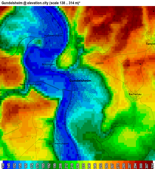
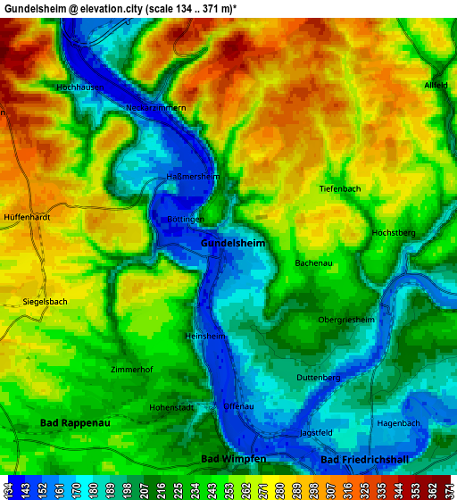
Below is the Elevation map of Gundelsheim, which displays elevation range with different colors. Scale of the first map is from 138 to 314 m (453 to 1030 ft) with average elevation of 218.9 meters (=718 ft) [note 1]
These maps also provides idea of topography and contour of this city, they are displayed at different zoom levels. More info about maps, scale and edge coordinates you can find below images.
| \ | Map #1 | Map #2 | Topo.Map |
| Scale [m] | 138..314 m | 134..371 m | × |
| Scale [ft] | 453..1030 ft | 440..1217 ft | × |
| Average | 218.9 m = 718 ft | 236.6 m = 776 ft | × |
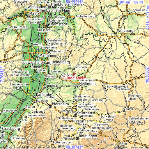
| Width | 6.37 km = 4 mi | 12.75 km = 7.9 mi | 204 km = 126.8 mi |
| Height | 6.37 km = 4 mi | 12.75 km = 7.9 mi | 204 km = 126.8 mi |
| ↑Max Latitude | 49.311958° | 49.340599° | 50.19211° |
| Latitude at center | 49.2833° | 49.2833° | 49.2833° |
| ↓Min Latitude | 49.254625° | 49.225934° | 48.35743° |
| ← Min Longitude | 9.116425° | 9.072479° | 7.75412° |
| Longitude center | 9.16037° | 9.16037° | 9.16037° |
| →Max Longitude | 9.204315° | 9.248261° | 10.56662° |
Nearby cities:
Cities around Gundelsheim sort by population:
• Mosbach elevation 186 m
7.8 km,  355°
355°
• Bad Rappenau 232 m
6.5 km,  220°
220°
• Bad Wimpfen 208 m
6 km,  182°
182°
• Oedheim 160 m
8.3 km,  125°
125°
• Obrigheim 150 m
9.1 km,  326°
326°
• Neudenau 182 m
8 km,  83°
83°
• Haßmersheim 151 m
2 km,  337°
337°
• Untereisesheim 160 m
8.6 km,  159°
159°
• Offenau 150 m
4.2 km, 179°
• Hüffenhardt 303 m
5.8 km,  279°
279°
• Siegelsbach 278 m
5.3 km,  253°
253°
• Neckarzimmern 153 m
4.5 km, 333°
Multilingual:
 En español:
Gundelsheim elevación 155 m.
 En France:
Gundelsheim élévation 155 m.
 Auf Deutsch:
Gundelsheim höhe über dem Meeresspiegel ist 155 m.

Sources and notes:
- [note 1] Map square and city borders are not equal. Map elevation data is calculated only from area inside that square.
- [src 1] Elevation data from geonames database provided with same terms of usage.
- [src 2] The elevation map of Gundelsheim is generated using elevation data from NASA's 3 arcsec (90m) resolution SRTM data.
- [src 3] Base (background) map © OpenStreetMap contributors tiles are generated by Geofabrik and OpenTopoMap.
Copyright & License:
This Gundelsheim Elevation Map is licensed under CC BY-SA. You may reuse any part from this page, if you give a proper credit by linking to this URL:
 More info on terms of use page.