Haag in Oberbayern elevation
Haag in Oberbayern (Bavaria, Upper Bavaria), Germany elevation is 540 meters and Haag in Oberbayern elevation in feet is 1772 ft above sea level [src 1]. Haag in Oberbayern is a populated place (feature code) with elevation that is 282 meters (925 ft) bigger than average city elevation in Germany.
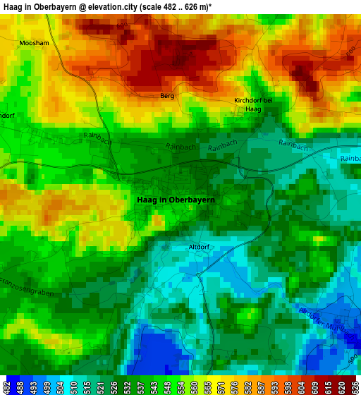
Below is the Elevation map of Haag in Oberbayern, which displays elevation range with different colors. Scale of the first map is from 482 to 626 m (1581 to 2054 ft) with average elevation of 545.9 meters (=1791 ft) [note 1]
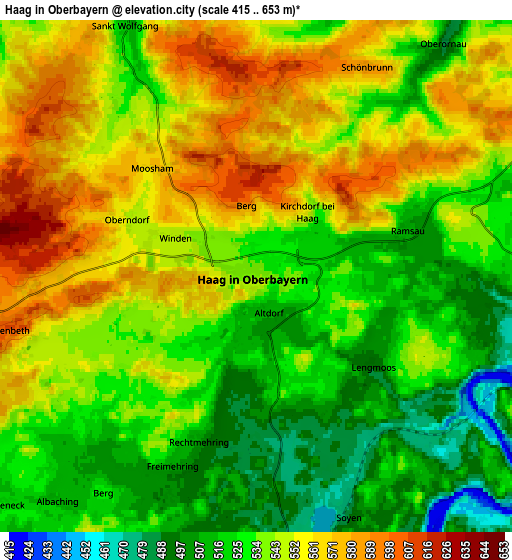
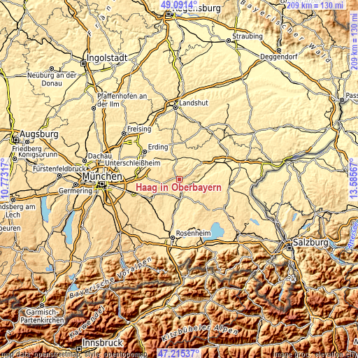
These maps also provides idea of topography and contour of this city, they are displayed at different zoom levels. More info about maps, scale and edge coordinates you can find below images.
| \ | Map #1 | Map #2 | Topo.Map |
| Scale [m] | 482..626 m | 415..653 m | × |
| Scale [ft] | 1581..2054 ft | 1362..2142 ft | × |
| Average | 545.9 m = 1791 ft | 540.1 m = 1772 ft | × |
| Width | 6.52 km = 4.1 mi | 13.04 km = 8.1 mi | 208.6 km = 129.6 mi |
| Height | 6.52 km = 4.1 mi | 13.04 km = 8.1 mi | 208.6 km = 129.6 mi |
| ↑Max Latitude | 48.191264° | 48.220552° | 49.0914° |
| Latitude at center | 48.16196° | 48.16196° | 48.16196° |
| ↓Min Latitude | 48.132639° | 48.103301° | 47.21537° |
| ← Min Longitude | 12.135475° | 12.091529° | 10.77317° |
| Longitude center | 12.17942° | 12.17942° | 12.17942° |
| →Max Longitude | 12.223365° | 12.267311° | 13.58567° |
Nearby cities:
Cities around Haag in Oberbayern sort by population:
• Altdorf elevation 508 m
1 km,  158°
158°
• Isen 519 m
10.7 km,  301°
301°
• Sankt Wolfgang 525 m
7 km,  330°
330°
• Gars 444 m
7.3 km,  97°
97°
• Babensham 488 m
10.9 km,  143°
143°
• Soyen 480 m
6.4 km, 159°
• Maitenbeth 602 m
6.5 km,  258°
258°
• Ramsau 509 m
3.9 km,  72°
72°
• Rechtmehring 508 m
5.1 km,  190°
190°
• Reichertsheim 526 m
8.8 km,  61°
61°
• Albaching 512 m
7.7 km,  221°
221°
• Kirchdorf 548 m
2 km,  40°
40°
Multilingual:
 En español:
Haag in Oberbayern elevación 540 m.
 En France:
Haag in Oberbayern élévation 540 m.
 Auf Deutsch:
Haag in Oberbayern höhe über dem Meeresspiegel ist 540 m.

Sources and notes:
- [note 1] Map square and city borders are not equal. Map elevation data is calculated only from area inside that square.
- [src 1] Elevation data from geonames database provided with same terms of usage.
- [src 2] The elevation map of Haag in Oberbayern is generated using elevation data from NASA's 3 arcsec (90m) resolution SRTM data.
- [src 3] Base (background) map © OpenStreetMap contributors tiles are generated by Geofabrik and OpenTopoMap.
Copyright & License:
This Haag in Oberbayern Elevation Map is licensed under CC BY-SA. You may reuse any part from this page, if you give a proper credit by linking to this URL:
 More info on terms of use page.