Hagnau elevation
Hagnau (Baden-Württemberg, Tübingen Region), Germany elevation is 416 meters and Hagnau elevation in feet is 1365 ft above sea level [src 1]. Hagnau is a populated place (feature code) with elevation that is 158 meters (518 ft) bigger than average city elevation in Germany.
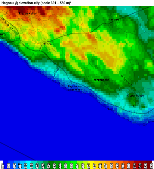
Below is the Elevation map of Hagnau, which displays elevation range with different colors. Scale of the first map is from 391 to 530 m (1283 to 1739 ft) with average elevation of 424.3 meters (=1392 ft) [note 1]
These maps also provides idea of topography and contour of this city, they are displayed at different zoom levels. More info about maps, scale and edge coordinates you can find below images.
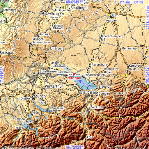
| \ | Map #1 | Topo.Map |
| Scale [m] | 391..530 m | × |
| Scale [ft] | 1283..1739 ft | × |
| Average | 424.3 m = 1392 ft | × |
| Width | 6.58 km = 4.1 mi | 210.6 km = 130.9 mi |
| Height | 6.58 km = 4.1 mi | 210.5 km = 130.8 mi |
| ↑Max Latitude | 47.706241° | 48.61493° |
| Latitude at center | 47.67666° | 47.67666° |
| ↓Min Latitude | 47.647063° | 46.72121° |
| ← Min Longitude | 9.273925° | 7.91162° |
| Longitude center | 9.31787° | 9.31787° |
| →Max Longitude | 9.361815° | 10.72412° |
Nearby cities:
Cities around Hagnau sort by population:
• Konstanz elevation 402 m
10.8 km,  260°
260°
• Friedrichshafen 405 m
12 km,  100°
100°
• Überlingen 431 m
15.1 km,  313°
313°
• Markdorf 441 m
7.2 km,  48°
48°
• Salem 436 m
9.8 km,  347°
347°
• Uhldingen-Mühlhofen 418 m
8.1 km,  321°
321°
• Immenstaad am Bodensee 408 m
3.8 km,  106°
106°
• Meersburg 426 m
4 km,  299°
299°
• Oberteuringen 448 m
12.5 km,  65°
65°
• Bermatingen 471 m
6.7 km,  20°
20°
• Fürstenberg 405 m
12.2 km,  271°
271°
• Daisendorf 514 m
5.5 km, 316°
Multilingual:
 En español:
Hagnau elevación 416 m.
 En France:
Hagnau élévation 416 m.


Sources and notes:
- [note 1] Map square and city borders are not equal. Map elevation data is calculated only from area inside that square.
- [src 1] Elevation data from geonames database provided with same terms of usage.
- [src 2] The elevation map of Hagnau is generated using elevation data from NASA's 3 arcsec (90m) resolution SRTM data.
- [src 3] Base (background) map © OpenStreetMap contributors tiles are generated by Geofabrik and OpenTopoMap.
Copyright & License:
This Hagnau Elevation Map is licensed under CC BY-SA. You may reuse any part from this page, if you give a proper credit by linking to this URL:
 More info on terms of use page.