Hirschau elevation
Hirschau (Bavaria, Upper Palatinate), Germany elevation is 414 meters and Hirschau elevation in feet is 1358 ft above sea level [src 1]. Hirschau is a populated place (feature code) with elevation that is 156 meters (512 ft) bigger than average city elevation in Germany.
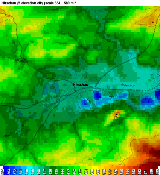
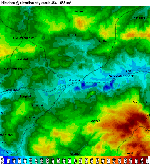
Below is the Elevation map of Hirschau, which displays elevation range with different colors. Scale of the first map is from 354 to 589 m (1161 to 1932 ft) with average elevation of 448.4 meters (=1471 ft) [note 1]
These maps also provides idea of topography and contour of this city, they are displayed at different zoom levels. More info about maps, scale and edge coordinates you can find below images.
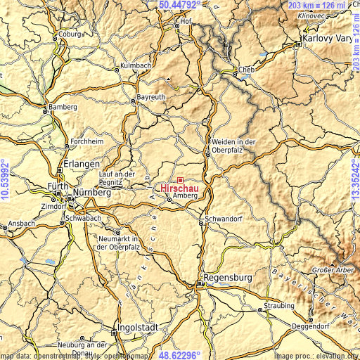
| \ | Map #1 | Map #2 | Topo.Map |
| Scale [m] | 354..589 m | 354..687 m | × |
| Scale [ft] | 1161..1932 ft | 1161..2254 ft | × |
| Average | 448.4 m = 1471 ft | 486.1 m = 1595 ft | × |
| Width | 6.34 km = 3.9 mi | 12.68 km = 7.9 mi | 202.9 km = 126.1 mi |
| Height | 6.34 km = 3.9 mi | 12.68 km = 7.9 mi | 202.9 km = 126.1 mi |
| ↑Max Latitude | 49.572466° | 49.600956° | 50.44792° |
| Latitude at center | 49.54396° | 49.54396° | 49.54396° |
| ↓Min Latitude | 49.515437° | 49.486898° | 48.62296° |
| ← Min Longitude | 11.902225° | 11.858279° | 10.53992° |
| Longitude center | 11.94617° | 11.94617° | 11.94617° |
| →Max Longitude | 11.990115° | 12.034061° | 13.35242° |
Nearby cities:
Cities around Hirschau sort by population:
• Amberg elevation 373 m
12.8 km,  208°
208°
• Kümmersbruck 396 m
14.5 km,  196°
196°
• Vilseck 405 m
13 km,  307°
307°
• Hahnbach 387 m
10.4 km,  263°
263°
• Schnaittenbach 408 m
4 km,  85°
85°
• Freudenberg 479 m
7.3 km,  158°
158°
• Weiherhammer 390 m
13.2 km,  41°
41°
• Poppenricht 419 m
13.1 km,  234°
234°
• Mantel 402 m
14 km,  29°
29°
• Freihung 419 m
9 km,  342°
342°
• Etzenricht 409 m
14.9 km,  48°
48°
• Kohlberg 479 m
7.5 km, 45°
Multilingual:
 En español:
Hirschau elevación 414 m.
 En France:
Hirschau élévation 414 m.
 Auf Deutsch:
Hirschau höhe über dem Meeresspiegel ist 414 m.

Sources and notes:
- [note 1] Map square and city borders are not equal. Map elevation data is calculated only from area inside that square.
- [src 1] Elevation data from geonames database provided with same terms of usage.
- [src 2] The elevation map of Hirschau is generated using elevation data from NASA's 3 arcsec (90m) resolution SRTM data.
- [src 3] Base (background) map © OpenStreetMap contributors tiles are generated by Geofabrik and OpenTopoMap.
Copyright & License:
This Hirschau Elevation Map is licensed under CC BY-SA. You may reuse any part from this page, if you give a proper credit by linking to this URL:
 More info on terms of use page.