Hof elevation
Hof (Bavaria, Upper Franconia), Germany elevation is 491 meters and Hof elevation in feet is 1611 ft above sea level [src 1]. Hof is a seat of a third-order administrative division (feature code) with elevation that is 233 meters (764 ft) bigger than average city elevation in Germany.
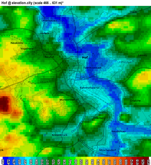
Below is the Elevation map of Hof, which displays elevation range with different colors. Scale of the first map is from 466 to 631 m (1529 to 2070 ft) with average elevation of 521.6 meters (=1711 ft) [note 1]
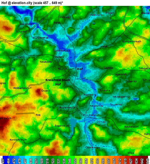
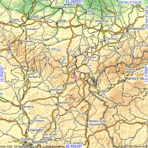
These maps also provides idea of topography and contour of this city, they are displayed at different zoom levels. More info about maps, scale and edge coordinates you can find below images.
| \ | Map #1 | Map #2 | Topo.Map |
| Scale [m] | 466..631 m | 457..649 m | × |
| Scale [ft] | 1529..2070 ft | 1499..2129 ft | × |
| Average | 521.6 m = 1711 ft | 533.5 m = 1750 ft | × |
| Width | 6.24 km = 3.9 mi | 12.48 km = 7.8 mi | 199.7 km = 124.1 mi |
| Height | 6.24 km = 3.9 mi | 12.48 km = 7.8 mi | 199.7 km = 124.1 mi |
| ↑Max Latitude | 50.341025° | 50.369063° | 51.20253° |
| Latitude at center | 50.31297° | 50.31297° | 50.31297° |
| ↓Min Latitude | 50.284899° | 50.25681° | 49.40645° |
| ← Min Longitude | 11.868665° | 11.824719° | 10.50636° |
| Longitude center | 11.91261° | 11.91261° | 11.91261° |
| →Max Longitude | 11.956555° | 12.000501° | 13.31886° |
Nearby cities:
Cities around Hof sort by population:
• Schwarzenbach an der Saale elevation 498 m
10.2 km,  170°
170°
• Rehau 521 m
11.2 km,  129°
129°
• Oberkotzau 490 m
5.8 km,  164°
164°
• Döhlau 523 m
4.2 km,  141°
141°
• Konradsreuth 545 m
6.8 km,  220°
220°
• Feilitzsch 515 m
6.1 km,  13°
13°
• Köditz 514 m
5 km,  296°
296°
• Regnitzlosau 518 m
9.9 km,  98°
98°
• Trogen 528 m
6.5 km,  23°
23°
• Leupoldsgrün 631 m
8.1 km,  259°
259°
• Gattendorf 557 m
6.1 km,  80°
80°
• Töpen 525 m
9.1 km,  342°
342°
Multilingual:
 En español:
Hof elevación 491 m.
 En France:
Hof élévation 491 m.


Sources and notes:
- [note 1] Map square and city borders are not equal. Map elevation data is calculated only from area inside that square.
- [src 1] Elevation data from geonames database provided with same terms of usage.
- [src 2] The elevation map of Hof is generated using elevation data from NASA's 3 arcsec (90m) resolution SRTM data.
- [src 3] Base (background) map © OpenStreetMap contributors tiles are generated by Geofabrik and OpenTopoMap.
Copyright & License:
This Hof Elevation Map is licensed under CC BY-SA. You may reuse any part from this page, if you give a proper credit by linking to this URL:
 More info on terms of use page.