Hof elevation
Hof (Rheinland-Pfalz), Germany elevation is 534 meters and Hof elevation in feet is 1752 ft above sea level [src 1]. Hof is a seat of a fourth-order administrative division (feature code) with elevation that is 276 meters (906 ft) bigger than average city elevation in Germany.
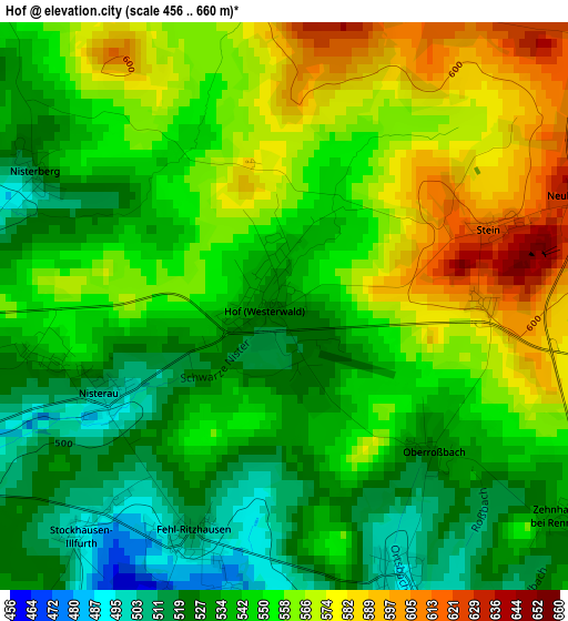
Below is the Elevation map of Hof, which displays elevation range with different colors. Scale of the first map is from 456 to 660 m (1496 to 2165 ft) with average elevation of 548.9 meters (=1801 ft) [note 1]
These maps also provides idea of topography and contour of this city, they are displayed at different zoom levels. More info about maps, scale and edge coordinates you can find below images.
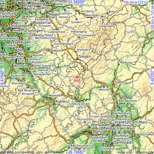
| \ | Map #1 | Topo.Map |
| Scale [m] | 456..660 m | × |
| Scale [ft] | 1496..2165 ft | × |
| Average | 548.9 m = 1801 ft | × |
| Width | 6.19 km = 3.8 mi | 198.2 km = 123.2 mi |
| Height | 6.19 km = 3.8 mi | 198.2 km = 123.2 mi |
| ↑Max Latitude | 50.694516° | 51.54955° |
| Latitude at center | 50.66667° | 50.66667° |
| ↓Min Latitude | 50.638808° | 49.76687° |
| ← Min Longitude | 7.972725° | 6.61042° |
| Longitude center | 8.01667° | 8.01667° |
| →Max Longitude | 8.060615° | 9.42292° |
Nearby cities:
Cities around Hof sort by population:
• Bad Marienberg elevation 448 m
5.1 km,  247°
247°
• Daaden 355 m
8.2 km,  334°
334°
• Rennerod 455 m
7.4 km,  151°
151°
• Höhn 507 m
6 km,  202°
202°
• Weitefeld 457 m
9 km,  316°
316°
• Unnau 382 m
7.9 km,  255°
255°
• Hellenhahn-Schellenberg 473 m
6 km,  173°
173°
• Friedewald 456 m
6.3 km, 321°
• Derschen 432 m
6 km,  337°
337°
• Langenbach bei Marienberg 395 m
5.8 km,  236°
236°
• Pottum 440 m
7.5 km,  189°
189°
• Rehe 541 m
8 km,  117°
117°
Multilingual:
 En español:
Hof elevación 534 m.
 En France:
Hof élévation 534 m.


Sources and notes:
- [note 1] Map square and city borders are not equal. Map elevation data is calculated only from area inside that square.
- [src 1] Elevation data from geonames database provided with same terms of usage.
- [src 2] The elevation map of Hof is generated using elevation data from NASA's 3 arcsec (90m) resolution SRTM data.
- [src 3] Base (background) map © OpenStreetMap contributors tiles are generated by Geofabrik and OpenTopoMap.
Copyright & License:
This Hof Elevation Map is licensed under CC BY-SA. You may reuse any part from this page, if you give a proper credit by linking to this URL:
 More info on terms of use page.