Hofkirchen elevation
Hofkirchen (Bavaria, Lower Bavaria), Germany elevation is 309 meters and Hofkirchen elevation in feet is 1014 ft above sea level [src 1]. Hofkirchen is a populated place (feature code) with elevation that is 51 meters (167 ft) bigger than average city elevation in Germany.
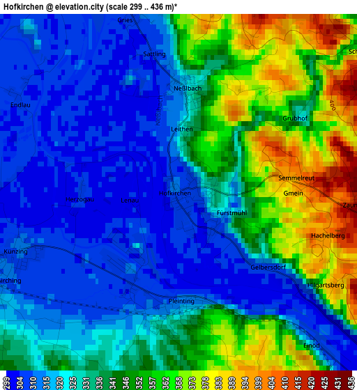
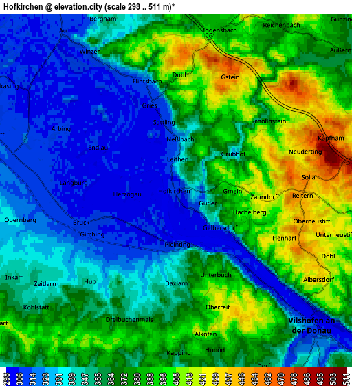
Below is the Elevation map of Hofkirchen, which displays elevation range with different colors. Scale of the first map is from 299 to 436 m (981 to 1430 ft) with average elevation of 334.5 meters (=1097 ft) [note 1]
These maps also provides idea of topography and contour of this city, they are displayed at different zoom levels. More info about maps, scale and edge coordinates you can find below images.
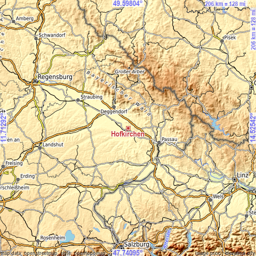
| \ | Map #1 | Map #2 | Topo.Map |
| Scale [m] | 299..436 m | 298..511 m | × |
| Scale [ft] | 981..1430 ft | 978..1677 ft | × |
| Average | 334.5 m = 1097 ft | 361.3 m = 1185 ft | × |
| Width | 6.45 km = 4 mi | 12.91 km = 8 mi | 206.5 km = 128.3 mi |
| Height | 6.45 km = 4 mi | 12.91 km = 8 mi | 206.5 km = 128.3 mi |
| ↑Max Latitude | 48.707058° | 48.73605° | 49.59804° |
| Latitude at center | 48.67805° | 48.67805° | 48.67805° |
| ↓Min Latitude | 48.649025° | 48.619983° | 47.74095° |
| ← Min Longitude | 13.075225° | 13.031279° | 11.71292° |
| Longitude center | 13.11917° | 13.11917° | 13.11917° |
| →Max Longitude | 13.163115° | 13.207061° | 14.52542° |
Nearby cities:
Cities around Hofkirchen sort by population:
• Vilshofen elevation 319 m
7.8 km,  136°
136°
• Osterhofen 319 m
7.5 km,  288°
288°
• Hengersberg 322 m
11.5 km,  335°
335°
• Schöllnach 381 m
9.5 km,  26°
26°
• Aldersbach 330 m
10.1 km,  192°
192°
• Winzer 312 m
5.8 km,  328°
328°
• Künzing 308 m
2.9 km,  244°
244°
• Aidenbach 356 m
12.2 km, 190°
• Iggensbach 382 m
6 km,  16°
16°
• Niederalteich 311 m
12 km,  324°
324°
• Reut 364 m
9.6 km,  178°
178°
• Außernzell 374 m
8 km,  50°
50°
Multilingual:
 En español:
Hofkirchen elevación 309 m.
 En France:
Hofkirchen élévation 309 m.
 Auf Deutsch:
Hofkirchen höhe über dem Meeresspiegel ist 309 m.

Sources and notes:
- [note 1] Map square and city borders are not equal. Map elevation data is calculated only from area inside that square.
- [src 1] Elevation data from geonames database provided with same terms of usage.
- [src 2] The elevation map of Hofkirchen is generated using elevation data from NASA's 3 arcsec (90m) resolution SRTM data.
- [src 3] Base (background) map © OpenStreetMap contributors tiles are generated by Geofabrik and OpenTopoMap.
Copyright & License:
This Hofkirchen Elevation Map is licensed under CC BY-SA. You may reuse any part from this page, if you give a proper credit by linking to this URL:
 More info on terms of use page.