Ihringen elevation
Ihringen (Baden-Württemberg, Freiburg Region), Germany elevation is 198 meters and Ihringen elevation in feet is 650 ft above sea level [src 1]. Ihringen is a seat of a fourth-order administrative division (feature code) with elevation that is 60 meters (197 ft) smaller than average city elevation in Germany.
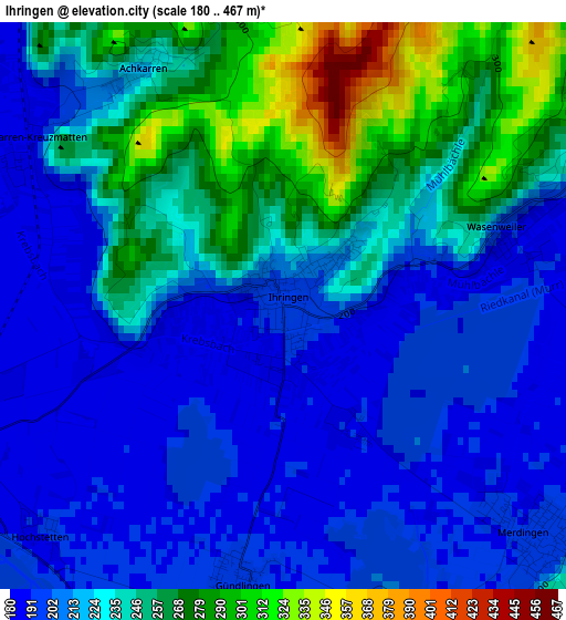
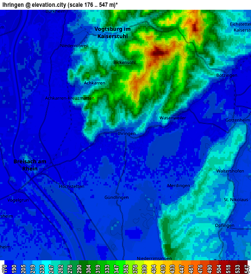
Below is the Elevation map of Ihringen, which displays elevation range with different colors. Scale of the first map is from 180 to 467 m (591 to 1532 ft) with average elevation of 229 meters (=751 ft) [note 1]
These maps also provides idea of topography and contour of this city, they are displayed at different zoom levels. More info about maps, scale and edge coordinates you can find below images.
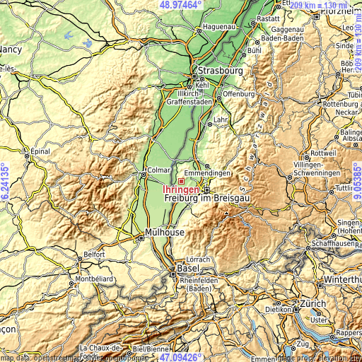
| \ | Map #1 | Map #2 | Topo.Map |
| Scale [m] | 180..467 m | 176..547 m | × |
| Scale [ft] | 591..1532 ft | 577..1795 ft | × |
| Average | 229 m = 751 ft | 224.6 m = 737 ft | × |
| Width | 6.53 km = 4.1 mi | 13.07 km = 8.1 mi | 209.1 km = 129.9 mi |
| Height | 6.53 km = 4.1 mi | 13.07 km = 8.1 mi | 209.1 km = 129.9 mi |
| ↑Max Latitude | 48.072402° | 48.101758° | 48.97464° |
| Latitude at center | 48.04303° | 48.04303° | 48.04303° |
| ↓Min Latitude | 48.013641° | 47.984235° | 47.09426° |
| ← Min Longitude | 7.603655° | 7.559709° | 6.24135° |
| Longitude center | 7.6476° | 7.6476° | 7.6476° |
| →Max Longitude | 7.691545° | 7.735491° | 9.05385° |
Nearby cities:
Cities around Ihringen sort by population:
• Breisach am Rhein elevation 189 m
4.9 km,  256°
256°
• Endingen 182 m
11.7 km,  19°
19°
• Vogtsburg 302 m
6 km,  355°
355°
• Bötzingen 192 m
6.8 km,  57°
57°
• Umkirch 206 m
8.9 km,  96°
96°
• Hartheim 201 m
12.2 km,  184°
184°
• Bahlingen 188 m
11 km,  38°
38°
• Sasbach 178 m
10.9 km,  347°
347°
• Eichstetten 192 m
9.1 km,  51°
51°
• Merdingen 193 m
4 km,  137°
137°
• Gottenheim 191 m
6.4 km,  83°
83°
• Oberrotweil 215 m
5.3 km, 350°
Multilingual:
 En español:
Ihringen elevación 198 m.
 En France:
Ihringen élévation 198 m.
 Auf Deutsch:
Ihringen höhe über dem Meeresspiegel ist 198 m.

Sources and notes:
- [note 1] Map square and city borders are not equal. Map elevation data is calculated only from area inside that square.
- [src 1] Elevation data from geonames database provided with same terms of usage.
- [src 2] The elevation map of Ihringen is generated using elevation data from NASA's 3 arcsec (90m) resolution SRTM data.
- [src 3] Base (background) map © OpenStreetMap contributors tiles are generated by Geofabrik and OpenTopoMap.
Copyright & License:
This Ihringen Elevation Map is licensed under CC BY-SA. You may reuse any part from this page, if you give a proper credit by linking to this URL:
 More info on terms of use page.