Illingen elevation
Illingen (Saarland), Germany elevation is 294 meters and Illingen elevation in feet is 965 ft above sea level [src 1]. Illingen is a populated place (feature code) with elevation that is 36 meters (118 ft) bigger than average city elevation in Germany.
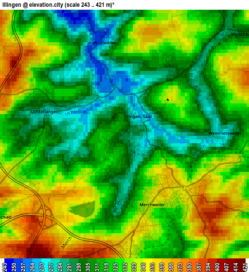
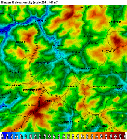
Below is the Elevation map of Illingen, which displays elevation range with different colors. Scale of the first map is from 243 to 421 m (797 to 1381 ft) with average elevation of 323.5 meters (=1061 ft) [note 1]
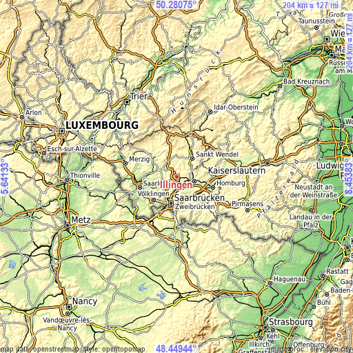
These maps also provides idea of topography and contour of this city, they are displayed at different zoom levels. More info about maps, scale and edge coordinates you can find below images.
| \ | Map #1 | Map #2 | Topo.Map |
| Scale [m] | 243..421 m | 226..441 m | × |
| Scale [ft] | 797..1381 ft | 741..1447 ft | × |
| Average | 323.5 m = 1061 ft | 328.6 m = 1078 ft | × |
| Width | 6.36 km = 4 mi | 12.73 km = 7.9 mi | 203.6 km = 126.5 mi |
| Height | 6.36 km = 4 mi | 12.73 km = 7.9 mi | 203.6 km = 126.5 mi |
| ↑Max Latitude | 49.402226° | 49.430814° | 50.28075° |
| Latitude at center | 49.37362° | 49.37362° | 49.37362° |
| ↓Min Latitude | 49.344998° | 49.316359° | 48.44944° |
| ← Min Longitude | 7.003635° | 6.959689° | 5.64133° |
| Longitude center | 7.04758° | 7.04758° | 7.04758° |
| →Max Longitude | 7.091525° | 7.135471° | 8.45383° |
Nearby cities:
Cities around Illingen sort by population:
• Neunkirchen elevation 289 m
10.2 km,  108°
108°
• Heusweiler 228 m
9.4 km,  243°
243°
• Sulzbach 248 m
8.3 km,  175°
175°
• Eppelborn 244 m
6.5 km,  296°
296°
• Schiffweiler 295 m
6.3 km,  97°
97°
• Ottweiler 254 m
9 km,  69°
69°
• Spiesen-Elversberg 353 m
8.9 km,  135°
135°
• Quierschied 256 m
6.3 km, 178°
• Friedrichsthal 309 m
6.2 km,  145°
145°
• Marpingen 285 m
8.8 km,  5°
5°
• Merchweiler 357 m
2.6 km, 176°
• Mainzweiler 305 m
7 km,  46°
46°
Multilingual:
 En español:
Illingen elevación 294 m.
 En France:
Illingen élévation 294 m.
 Auf Deutsch:
Illingen höhe über dem Meeresspiegel ist 294 m.

Sources and notes:
- [note 1] Map square and city borders are not equal. Map elevation data is calculated only from area inside that square.
- [src 1] Elevation data from geonames database provided with same terms of usage.
- [src 2] The elevation map of Illingen is generated using elevation data from NASA's 3 arcsec (90m) resolution SRTM data.
- [src 3] Base (background) map © OpenStreetMap contributors tiles are generated by Geofabrik and OpenTopoMap.
Copyright & License:
This Illingen Elevation Map is licensed under CC BY-SA. You may reuse any part from this page, if you give a proper credit by linking to this URL:
 More info on terms of use page.