Ittlingen elevation
Ittlingen (Baden-Württemberg, Regierungsbezirk Stuttgart), Germany elevation is 197 meters and Ittlingen elevation in feet is 646 ft above sea level [src 1]. Ittlingen is a seat of a fourth-order administrative division (feature code) with elevation that is 61 meters (200 ft) smaller than average city elevation in Germany.
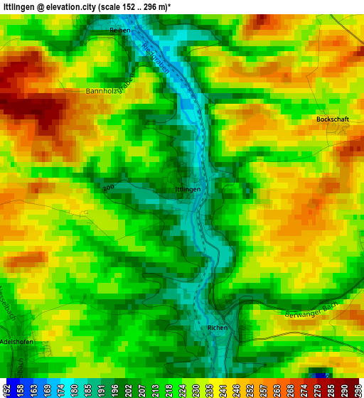
Below is the Elevation map of Ittlingen, which displays elevation range with different colors. Scale of the first map is from 152 to 296 m (499 to 971 ft) with average elevation of 224.3 meters (=736 ft) [note 1]
These maps also provides idea of topography and contour of this city, they are displayed at different zoom levels. More info about maps, scale and edge coordinates you can find below images.
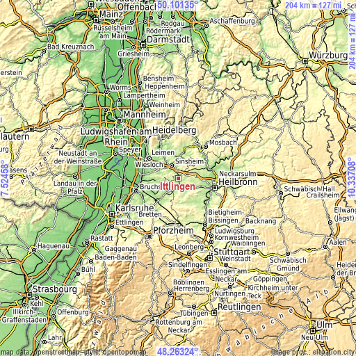
| \ | Map #1 | Topo.Map |
| Scale [m] | 152..296 m | × |
| Scale [ft] | 499..971 ft | × |
| Average | 224.3 m = 736 ft | × |
| Width | 6.39 km = 4 mi | 204.4 km = 127 mi |
| Height | 6.39 km = 4 mi | 204.4 km = 127 mi |
| ↑Max Latitude | 49.219542° | 50.10135° |
| Latitude at center | 49.19083° | 49.19083° |
| ↓Min Latitude | 49.162102° | 48.26324° |
| ← Min Longitude | 8.886885° | 7.52458° |
| Longitude center | 8.93083° | 8.93083° |
| →Max Longitude | 8.974775° | 10.33708° |
Nearby cities:
Cities around Ittlingen sort by population:
• Sinsheim elevation 162 m
7.9 km,  331°
331°
• Eppingen 190 m
6.2 km,  192°
192°
• Bad Rappenau 232 m
13.5 km,  66°
66°
• Schwaigern 202 m
10.4 km,  119°
119°
• Waibstadt 182 m
11.6 km,  355°
355°
• Kirchardt 227 m
4.7 km, 70°
• Gemmingen 212 m
5.3 km,  135°
135°
• Sulzfeld 195 m
11 km,  209°
209°
• Neckarbischofsheim 187 m
12 km,  11°
11°
• Massenbachhausen 210 m
8.3 km,  100°
100°
• Zaisenhausen 185 m
12.7 km,  222°
222°
• Balzfeld 171 m
13.5 km,  310°
310°
Multilingual:
 En español:
Ittlingen elevación 197 m.
 En France:
Ittlingen élévation 197 m.
 Auf Deutsch:
Ittlingen höhe über dem Meeresspiegel ist 197 m.

Sources and notes:
- [note 1] Map square and city borders are not equal. Map elevation data is calculated only from area inside that square.
- [src 1] Elevation data from geonames database provided with same terms of usage.
- [src 2] The elevation map of Ittlingen is generated using elevation data from NASA's 3 arcsec (90m) resolution SRTM data.
- [src 3] Base (background) map © OpenStreetMap contributors tiles are generated by Geofabrik and OpenTopoMap.
Copyright & License:
This Ittlingen Elevation Map is licensed under CC BY-SA. You may reuse any part from this page, if you give a proper credit by linking to this URL:
 More info on terms of use page.