Ketzin elevation
Ketzin (Brandenburg), Germany elevation is 33 meters and Ketzin elevation in feet is 108 ft above sea level [src 1]. Ketzin is a populated place (feature code) with elevation that is 225 meters (738 ft) smaller than average city elevation in Germany.
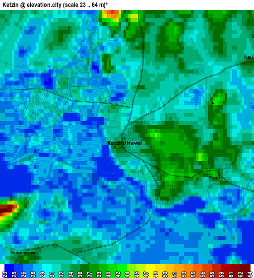
Below is the Elevation map of Ketzin, which displays elevation range with different colors. Scale of the first map is from 23 to 64 m (75 to 210 ft) with average elevation of 31.2 meters (=102 ft) [note 1]
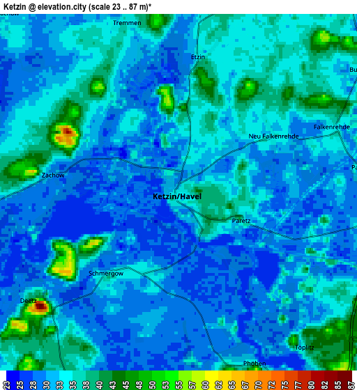
These maps also provides idea of topography and contour of this city, they are displayed at different zoom levels. More info about maps, scale and edge coordinates you can find below images.
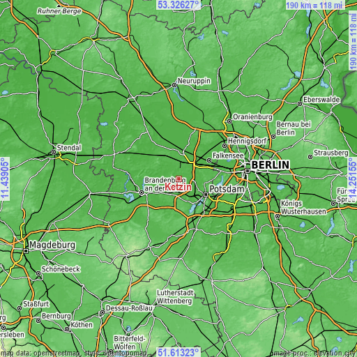
| \ | Map #1 | Map #2 | Topo.Map |
| Scale [m] | 23..64 m | 23..87 m | × |
| Scale [ft] | 75..210 ft | 75..285 ft | × |
| Average | 31.2 m = 102 ft | 32.9 m = 108 ft | × |
| Width | 5.95 km = 3.7 mi | 11.9 km = 7.4 mi | 190.5 km = 118.4 mi |
| Height | 5.95 km = 3.7 mi | 11.9 km = 7.4 mi | 190.5 km = 118.4 mi |
| ↑Max Latitude | 52.504847° | 52.531589° | 53.32627° |
| Latitude at center | 52.47809° | 52.47809° | 52.47809° |
| ↓Min Latitude | 52.451316° | 52.424526° | 51.61323° |
| ← Min Longitude | 12.801355° | 12.757409° | 11.43905° |
| Longitude center | 12.8453° | 12.8453° | 12.8453° |
| →Max Longitude | 12.889245° | 12.933191° | 14.25155° |
Nearby cities:
Cities around Ketzin sort by population:
• Potsdam elevation 34 m
17.3 km,  120°
120°
• Brandenburg an der Havel 57 m
21.1 km,  251°
251°
• Falkensee 31 m
19.1 km,  61°
61°
• Werder 33 m
12.6 km,  151°
151°
• Nauen 37 m
14.5 km,  7°
7°
• Kladow 50 m
20.4 km,  97°
97°
• Kloster Lehnin 38 m
18.9 km,  201°
201°
• Brieselang 30 m
15.7 km,  41°
41°
• Groß Kreutz 32 m
9.5 km,  208°
208°
• Wustermark 33 m
10.7 km, 41°
• Dallgow-Döberitz 35 m
16.1 km, 63°
• Roskow 33 m
8.6 km,  265°
265°
Multilingual:
 En español:
Ketzin elevación 33 m.
 En France:
Ketzin/Havel élévation 33 m.
 Auf Deutsch:
Ketzin/Havel höhe über dem Meeresspiegel ist 33 m.

Sources and notes:
- [note 1] Map square and city borders are not equal. Map elevation data is calculated only from area inside that square.
- [src 1] Elevation data from geonames database provided with same terms of usage.
- [src 2] The elevation map of Ketzin is generated using elevation data from NASA's 3 arcsec (90m) resolution SRTM data.
- [src 3] Base (background) map © OpenStreetMap contributors tiles are generated by Geofabrik and OpenTopoMap.
Copyright & License:
This Ketzin Elevation Map is licensed under CC BY-SA. You may reuse any part from this page, if you give a proper credit by linking to this URL:
 More info on terms of use page.