Kirchdorf am Inn elevation
Kirchdorf am Inn (Bavaria, Lower Bavaria), Germany elevation is 351 meters and Kirchdorf am Inn elevation in feet is 1152 ft above sea level [src 1]. Kirchdorf am Inn is a populated place (feature code) with elevation that is 93 meters (305 ft) bigger than average city elevation in Germany.
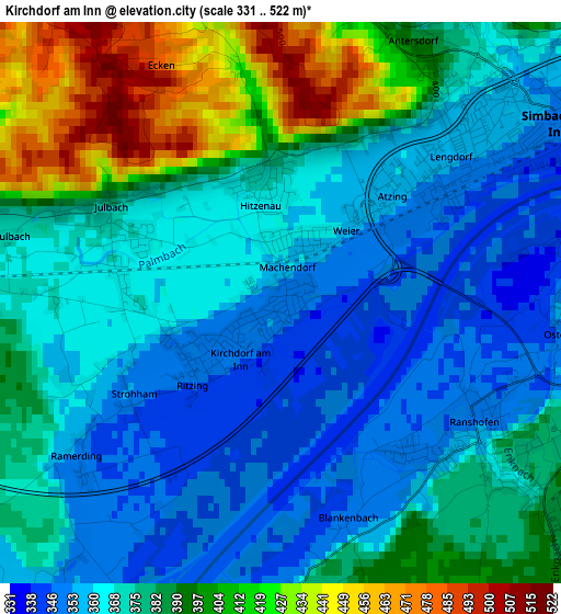
Below is the Elevation map of Kirchdorf am Inn, which displays elevation range with different colors. Scale of the first map is from 331 to 522 m (1086 to 1713 ft) with average elevation of 378 meters (=1240 ft) [note 1]
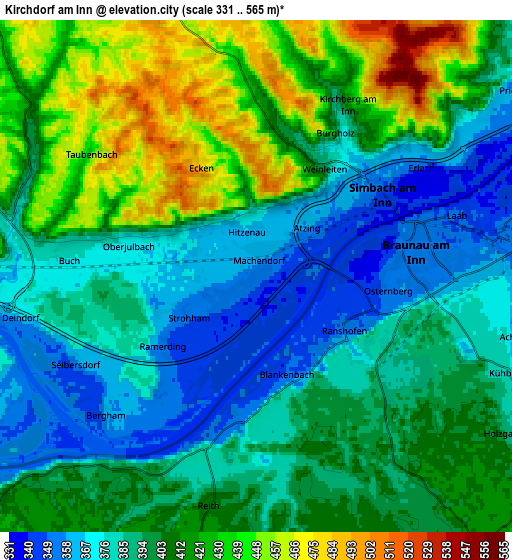
These maps also provides idea of topography and contour of this city, they are displayed at different zoom levels. More info about maps, scale and edge coordinates you can find below images.
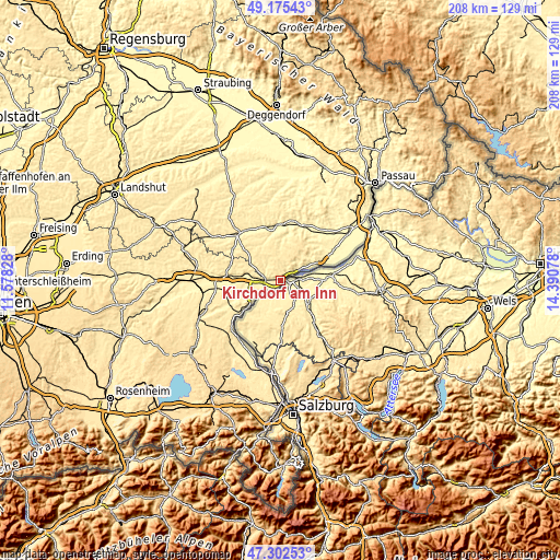
| \ | Map #1 | Map #2 | Topo.Map |
| Scale [m] | 331..522 m | 331..565 m | × |
| Scale [ft] | 1086..1713 ft | 1086..1854 ft | × |
| Average | 378 m = 1240 ft | 400.9 m = 1315 ft | × |
| Width | 6.51 km = 4 mi | 13.02 km = 8.1 mi | 208.2 km = 129.4 mi |
| Height | 6.51 km = 4 mi | 13.02 km = 8.1 mi | 208.2 km = 129.4 mi |
| ↑Max Latitude | 48.276805° | 48.306044° | 49.17543° |
| Latitude at center | 48.24755° | 48.24755° | 48.24755° |
| ↓Min Latitude | 48.218278° | 48.188989° | 47.30253° |
| ← Min Longitude | 12.940585° | 12.896639° | 11.57828° |
| Longitude center | 12.98453° | 12.98453° | 12.98453° |
| →Max Longitude | 13.028475° | 13.072421° | 14.39078° |
Nearby cities:
Cities around Kirchdorf am Inn sort by population:
• Burghausen elevation 422 m
14.3 km,  232°
232°
• Simbach am Inn 355 m
3.5 km,  55°
55°
• Tann 447 m
10.1 km,  317°
317°
• Marktl 365 m
10.4 km,  274°
274°
• Haiming 353 m
7.1 km,  241°
241°
• Julbach 368 m
2.1 km,  290°
290°
• Zeilarn 445 m
12 km,  299°
299°
• Ering 343 m
13.5 km, 64°
• Stubenberg 473 m
10.6 km,  43°
43°
• Erlbach 473 m
16 km, 291°
• Perach 387 m
16.3 km,  277°
277°
• Stammham 367 m
7.5 km, 272°
Multilingual:
 En español:
Kirchdorf am Inn elevación 351 m.
 En France:
Kirchdorf am Inn élévation 351 m.
 Auf Deutsch:
Kirchdorf am Inn höhe über dem Meeresspiegel ist 351 m.

Sources and notes:
- [note 1] Map square and city borders are not equal. Map elevation data is calculated only from area inside that square.
- [src 1] Elevation data from geonames database provided with same terms of usage.
- [src 2] The elevation map of Kirchdorf am Inn is generated using elevation data from NASA's 3 arcsec (90m) resolution SRTM data.
- [src 3] Base (background) map © OpenStreetMap contributors tiles are generated by Geofabrik and OpenTopoMap.
Copyright & License:
This Kirchdorf am Inn Elevation Map is licensed under CC BY-SA. You may reuse any part from this page, if you give a proper credit by linking to this URL:
 More info on terms of use page.