Kirchheim elevation
Kirchheim (Bavaria, Swabia), Germany elevation is 579 meters and Kirchheim elevation in feet is 1900 ft above sea level [src 1]. Kirchheim is a populated place (feature code) with elevation that is 321 meters (1053 ft) bigger than average city elevation in Germany.
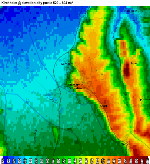
Below is the Elevation map of Kirchheim, which displays elevation range with different colors. Scale of the first map is from 520 to 604 m (1706 to 1982 ft) with average elevation of 547.8 meters (=1797 ft) [note 1]
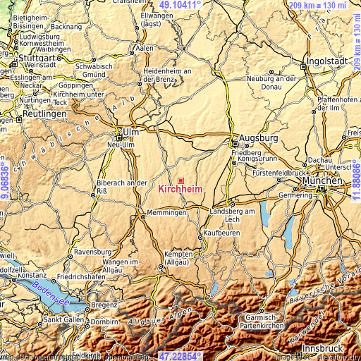
These maps also provides idea of topography and contour of this city, they are displayed at different zoom levels. More info about maps, scale and edge coordinates you can find below images.
| \ | Map #1 | Topo.Map |
| Scale [m] | 520..604 m | × |
| Scale [ft] | 1706..1982 ft | × |
| Average | 547.8 m = 1797 ft | × |
| Width | 6.52 km = 4.1 mi | 208.5 km = 129.6 mi |
| Height | 6.52 km = 4.1 mi | 208.5 km = 129.6 mi |
| ↑Max Latitude | 48.204197° | 49.10411° |
| Latitude at center | 48.1749° | 48.1749° |
| ↓Min Latitude | 48.145586° | 47.22854° |
| ← Min Longitude | 10.430665° | 9.06836° |
| Longitude center | 10.47461° | 10.47461° |
| →Max Longitude | 10.518555° | 11.88086° |
Nearby cities:
Cities around Kirchheim sort by population:
• Ursberg elevation 513 m
10.2 km,  347°
347°
• Pfaffenhausen 564 m
6.4 km,  193°
193°
• Markt Wald 636 m
9 km,  118°
118°
• Breitenbrunn 556 m
7.2 km,  230°
230°
• Eppishausen 553 m
3.3 km,  106°
106°
• Salgen 559 m
4.9 km,  176°
176°
• Balzhausen 521 m
7.6 km,  10°
10°
• Oberrieden 576 m
10.2 km,  200°
200°
• Aichen 509 m
7.7 km,  38°
38°
• Aletshausen 531 m
6.9 km,  292°
292°
• Walkertshofen 531 m
10.2 km,  55°
55°
• Mittelneufnach 554 m
9.1 km,  88°
88°
Multilingual:
 En español:
Kirchheim elevación 579 m.
 En France:
Kirchheim élévation 579 m.
 Auf Deutsch:
Kirchheim höhe über dem Meeresspiegel ist 579 m.

Sources and notes:
- [note 1] Map square and city borders are not equal. Map elevation data is calculated only from area inside that square.
- [src 1] Elevation data from geonames database provided with same terms of usage.
- [src 2] The elevation map of Kirchheim is generated using elevation data from NASA's 3 arcsec (90m) resolution SRTM data.
- [src 3] Base (background) map © OpenStreetMap contributors tiles are generated by Geofabrik and OpenTopoMap.
Copyright & License:
This Kirchheim Elevation Map is licensed under CC BY-SA. You may reuse any part from this page, if you give a proper credit by linking to this URL:
 More info on terms of use page.