Kleinmaischeid elevation
Kleinmaischeid (Rheinland-Pfalz), Germany elevation is 302 meters and Kleinmaischeid elevation in feet is 991 ft above sea level [src 1]. Kleinmaischeid is a seat of a fourth-order administrative division (feature code) with elevation that is 44 meters (144 ft) bigger than average city elevation in Germany.
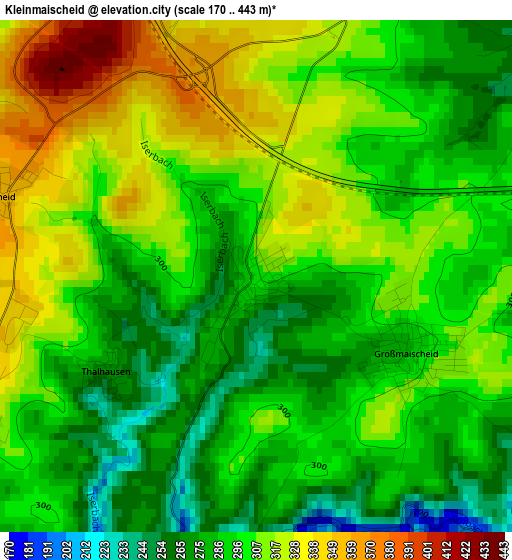
Below is the Elevation map of Kleinmaischeid, which displays elevation range with different colors. Scale of the first map is from 170 to 443 m (558 to 1453 ft) with average elevation of 299.5 meters (=983 ft) [note 1]
These maps also provides idea of topography and contour of this city, they are displayed at different zoom levels. More info about maps, scale and edge coordinates you can find below images.
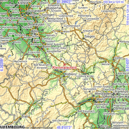
| \ | Map #1 | Topo.Map |
| Scale [m] | 170..443 m | × |
| Scale [ft] | 558..1453 ft | × |
| Average | 299.5 m = 983 ft | × |
| Width | 6.21 km = 3.9 mi | 198.9 km = 123.6 mi |
| Height | 6.21 km = 3.9 mi | 198.8 km = 123.5 mi |
| ↑Max Latitude | 50.541386° | 51.39923° |
| Latitude at center | 50.51345° | 50.51345° |
| ↓Min Latitude | 50.485497° | 49.61073° |
| ← Min Longitude | 7.564355° | 6.20205° |
| Longitude center | 7.6083° | 7.6083° |
| →Max Longitude | 7.652245° | 9.01455° |
Nearby cities:
Cities around Kleinmaischeid sort by population:
• Dierdorf elevation 244 m
4.8 km,  40°
40°
• Stromberg 300 m
6.2 km,  185°
185°
• Rengsdorf 269 m
7.8 km,  258°
258°
• Großmaischeid 312 m
2.3 km,  130°
130°
• Nauort 309 m
5.5 km,  161°
161°
• Raubach 224 m
6.9 km,  9°
9°
• Urbach-Überdorf 309 m
5.1 km,  342°
342°
• Hilgert 322 m
8.5 km,  138°
138°
• Anhausen 305 m
4.4 km,  250°
250°
• Bonefeld 345 m
8.5 km,  277°
277°
• Marienrachdorf 272 m
8.7 km,  62°
62°
• Dernbach 322 m
4.1 km,  351°
351°
Multilingual:
 En español:
Kleinmaischeid elevación 302 m.
 En France:
Kleinmaischeid élévation 302 m.
 Auf Deutsch:
Kleinmaischeid höhe über dem Meeresspiegel ist 302 m.

Sources and notes:
- [note 1] Map square and city borders are not equal. Map elevation data is calculated only from area inside that square.
- [src 1] Elevation data from geonames database provided with same terms of usage.
- [src 2] The elevation map of Kleinmaischeid is generated using elevation data from NASA's 3 arcsec (90m) resolution SRTM data.
- [src 3] Base (background) map © OpenStreetMap contributors tiles are generated by Geofabrik and OpenTopoMap.
Copyright & License:
This Kleinmaischeid Elevation Map is licensed under CC BY-SA. You may reuse any part from this page, if you give a proper credit by linking to this URL:
 More info on terms of use page.