Landscheid elevation
Landscheid (Rheinland-Pfalz), Germany elevation is 302 meters and Landscheid elevation in feet is 991 ft above sea level [src 1]. Landscheid is a seat of a fourth-order administrative division (feature code) with elevation that is 44 meters (144 ft) bigger than average city elevation in Germany.
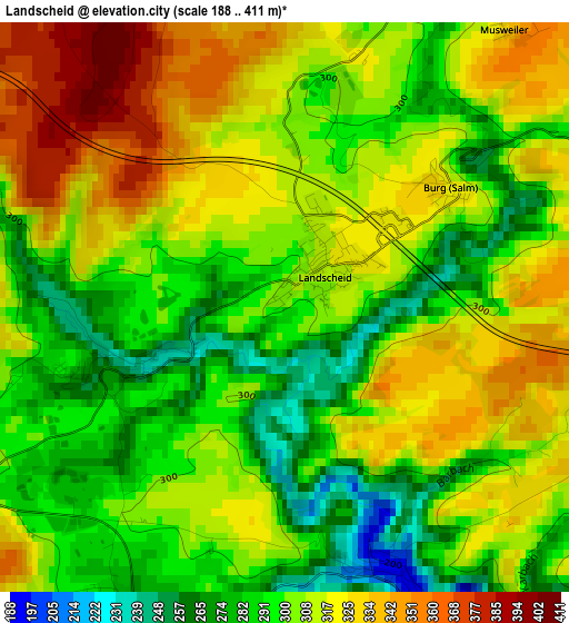
Below is the Elevation map of Landscheid, which displays elevation range with different colors. Scale of the first map is from 188 to 411 m (617 to 1348 ft) with average elevation of 306.4 meters (=1005 ft) [note 1]
These maps also provides idea of topography and contour of this city, they are displayed at different zoom levels. More info about maps, scale and edge coordinates you can find below images.
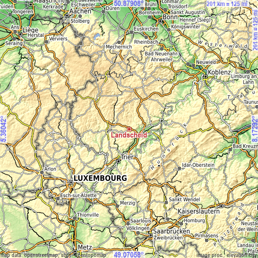
| \ | Map #1 | Topo.Map |
| Scale [m] | 188..411 m | × |
| Scale [ft] | 617..1348 ft | × |
| Average | 306.4 m = 1005 ft | × |
| Width | 6.28 km = 3.9 mi | 201.1 km = 125 mi |
| Height | 6.28 km = 3.9 mi | 201.1 km = 125 mi |
| ↑Max Latitude | 50.011579° | 50.87908° |
| Latitude at center | 49.98333° | 49.98333° |
| ↓Min Latitude | 49.955064° | 49.07058° |
| ← Min Longitude | 6.722725° | 5.36042° |
| Longitude center | 6.76667° | 6.76667° |
| →Max Longitude | 6.810615° | 8.17292° |
Nearby cities:
Cities around Landscheid sort by population:
• Wittlich elevation 178 m
9 km,  88°
88°
• Speicher 311 m
11 km,  239°
239°
• Zemmer 360 m
10.4 km,  207°
207°
• Salmtal 184 m
8.2 km,  133°
133°
• Hetzerath 171 m
11.7 km,  162°
162°
• Altrich 185 m
10.8 km,  105°
105°
• Dreis 175 m
6 km,  141°
141°
• Badem 355 m
10.9 km,  279°
279°
• Binsfeld 323 m
4 km, 242°
• Dudeldorf 277 m
9.3 km,  264°
264°
• Großlittgen 310 m
5.5 km,  24°
24°
• Herforst 314 m
6 km,  232°
232°
Multilingual:
 En español:
Landscheid elevación 302 m.
 En France:
Landscheid élévation 302 m.
 Auf Deutsch:
Landscheid höhe über dem Meeresspiegel ist 302 m.

Sources and notes:
- [note 1] Map square and city borders are not equal. Map elevation data is calculated only from area inside that square.
- [src 1] Elevation data from geonames database provided with same terms of usage.
- [src 2] The elevation map of Landscheid is generated using elevation data from NASA's 3 arcsec (90m) resolution SRTM data.
- [src 3] Base (background) map © OpenStreetMap contributors tiles are generated by Geofabrik and OpenTopoMap.
Copyright & License:
This Landscheid Elevation Map is licensed under CC BY-SA. You may reuse any part from this page, if you give a proper credit by linking to this URL:
 More info on terms of use page.