Laugna elevation
Laugna (Bavaria, Swabia), Germany elevation is 432 meters and Laugna elevation in feet is 1417 ft above sea level [src 1]. Laugna is a seat of a fourth-order administrative division (feature code) with elevation that is 174 meters (571 ft) bigger than average city elevation in Germany.
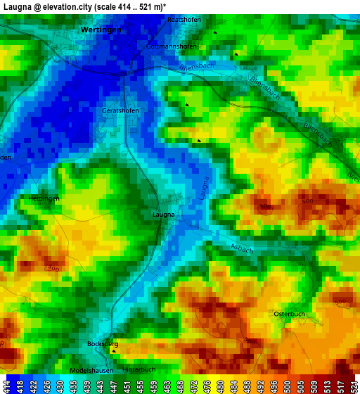
Below is the Elevation map of Laugna, which displays elevation range with different colors. Scale of the first map is from 414 to 521 m (1358 to 1709 ft) with average elevation of 457.9 meters (=1502 ft) [note 1]
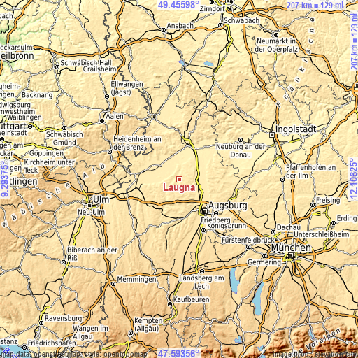
These maps also provides idea of topography and contour of this city, they are displayed at different zoom levels. More info about maps, scale and edge coordinates you can find below images.
| \ | Map #1 | Topo.Map |
| Scale [m] | 414..521 m | × |
| Scale [ft] | 1358..1709 ft | × |
| Average | 457.9 m = 1502 ft | × |
| Width | 6.47 km = 4 mi | 207.1 km = 128.7 mi |
| Height | 6.47 km = 4 mi | 207.1 km = 128.7 mi |
| ↑Max Latitude | 48.562422° | 49.45598° |
| Latitude at center | 48.53333° | 48.53333° |
| ↓Min Latitude | 48.504222° | 47.59356° |
| ← Min Longitude | 10.656055° | 9.29375° |
| Longitude center | 10.7° | 10.7° |
| →Max Longitude | 10.743945° | 12.10625° |
Nearby cities:
Cities around Laugna sort by population:
• Wertingen elevation 428 m
3.6 km,  337°
337°
• Buttenwiesen 409 m
7.5 km,  9°
9°
• Altenmünster 435 m
11.1 km,  226°
226°
• Welden 465 m
9.2 km,  198°
198°
• Biberbach 438 m
8.4 km,  101°
101°
• Emersacker 447 m
5.2 km, 201°
• Binswangen 421 m
5 km,  302°
302°
• Zusamaltheim 444 m
4.7 km,  266°
266°
• Villenbach 437 m
6.8 km,  246°
246°
• Bonstetten 508 m
10.4 km,  177°
177°
• Heretsried 505 m
8.6 km,  162°
162°
• Ehingen 448 m
10.4 km,  44°
44°
Multilingual:
 En español:
Laugna elevación 432 m.
 En France:
Laugna élévation 432 m.


Sources and notes:
- [note 1] Map square and city borders are not equal. Map elevation data is calculated only from area inside that square.
- [src 1] Elevation data from geonames database provided with same terms of usage.
- [src 2] The elevation map of Laugna is generated using elevation data from NASA's 3 arcsec (90m) resolution SRTM data.
- [src 3] Base (background) map © OpenStreetMap contributors tiles are generated by Geofabrik and OpenTopoMap.
Copyright & License:
This Laugna Elevation Map is licensed under CC BY-SA. You may reuse any part from this page, if you give a proper credit by linking to this URL:
 More info on terms of use page.