Lauterecken elevation
Lauterecken (Rheinland-Pfalz), Germany elevation is 171 meters and Lauterecken elevation in feet is 561 ft above sea level [src 1]. Lauterecken is a populated place (feature code) with elevation that is 87 meters (285 ft) smaller than average city elevation in Germany.
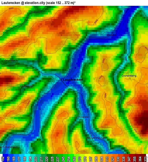
Below is the Elevation map of Lauterecken, which displays elevation range with different colors. Scale of the first map is from 152 to 372 m (499 to 1220 ft) with average elevation of 257.4 meters (=844 ft) [note 1]
These maps also provides idea of topography and contour of this city, they are displayed at different zoom levels. More info about maps, scale and edge coordinates you can find below images.
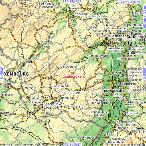
| \ | Map #1 | Topo.Map |
| Scale [m] | 152..372 m | × |
| Scale [ft] | 499..1220 ft | × |
| Average | 257.4 m = 844 ft | × |
| Width | 6.33 km = 3.9 mi | 202.5 km = 125.8 mi |
| Height | 6.33 km = 3.9 mi | 202.5 km = 125.8 mi |
| ↑Max Latitude | 49.678374° | 50.55192° |
| Latitude at center | 49.64993° | 49.64993° |
| ↓Min Latitude | 49.621469° | 48.73092° |
| ← Min Longitude | 7.548705° | 6.1864° |
| Longitude center | 7.59265° | 7.59265° |
| →Max Longitude | 7.636595° | 8.9989° |
Nearby cities:
Cities around Lauterecken sort by population:
• Altenglan elevation 201 m
14.3 km,  219°
219°
• Meisenheim 169 m
8.3 km,  40°
40°
• Niederkirchen 341 m
10.7 km,  133°
133°
• Wolfstein 201 m
7.4 km,  173°
173°
• Rammelsbach 214 m
16.1 km, 221°
• Odernheim 145 m
15.1 km,  32°
32°
• Staudernheim 141 m
15.7 km, 26°
• Meddersheim 165 m
14.2 km,  7°
7°
• Offenbach-Hundheim 177 m
4.7 km, 219°
• Sankt Julian 224 m
6.6 km,  235°
235°
• Olsbrücken 213 m
13.2 km,  158°
158°
• Obermoschel 184 m
15.6 km,  56°
56°
Multilingual:
 En español:
Lauterecken elevación 171 m.
 En France:
Lauterecken élévation 171 m.
 Auf Deutsch:
Lauterecken höhe über dem Meeresspiegel ist 171 m.

Sources and notes:
- [note 1] Map square and city borders are not equal. Map elevation data is calculated only from area inside that square.
- [src 1] Elevation data from geonames database provided with same terms of usage.
- [src 2] The elevation map of Lauterecken is generated using elevation data from NASA's 3 arcsec (90m) resolution SRTM data.
- [src 3] Base (background) map © OpenStreetMap contributors tiles are generated by Geofabrik and OpenTopoMap.
Copyright & License:
This Lauterecken Elevation Map is licensed under CC BY-SA. You may reuse any part from this page, if you give a proper credit by linking to this URL:
 More info on terms of use page.